The research of sea-land breeze (SLB) on the west coast of Bohai Bay based on field observation
Wei Gu , LaiYin Zhu , WeiJia Cui , Ning Li ,, JianOu Cong , YingJun Xu ,ShuQing Huang , HaiYang Yu , LanTao Li
1. State Key Laboratory of Earth Surface Processes and Resource Ecology, Beijing Normal University, Beijing 100875, China 2. Academy of Disaster Reduction and Emergency Management, Beijing Normal University, Beijing 100875, China 3. Cangzhou Meteorological Bureau of Hebei Province, Cangzhou, Hebei 061001, China
The research of sea-land breeze (SLB) on the west coast of Bohai Bay based on field observation
Wei Gu1, LaiYin Zhu1, WeiJia Cui1, Ning Li1,2*, JianOu Cong1, YingJun Xu1,ShuQing Huang1, HaiYang Yu3, LanTao Li1
1. State Key Laboratory of Earth Surface Processes and Resource Ecology, Beijing Normal University, Beijing 100875, China 2. Academy of Disaster Reduction and Emergency Management, Beijing Normal University, Beijing 100875, China 3. Cangzhou Meteorological Bureau of Hebei Province, Cangzhou, Hebei 061001, China
Four automatic meteorological stations were set up in a line from beach to inland perpendicular to the west coast of Bohai Bay.Wind direction and velocity at altitudes of 2 m, 4 m and 12 m were surveyed with 10 minute intervals. On "Sea-Land Breeze"(SLB) days, the transition from sea breeze to land breeze was very evident in the study area. Direction of sea breeze was basically perpendicular to the coast and mainly from the ENE and E. Duration of sea breeze varied by the stations’ distance to the coastline,and the near-coast wind velocity was larger than that of the inland and decreases as it reaches inland. There was increased development of SLB on sunny days than on overcast days. The term "Climatic Coastal Zone" can be defined for the area influenced by SLB, which reaches more than 74 km inland on a typical SLB day but less than 10 km on a non-typical SLB day.
Bohai Bay; sea-land breeze; meteorological observation; climatic coastal zone
1. Introduction
Bohai is an inland sea in China ranging from 37oN to 41oN. Well established ports such as Dalian, Yingkou,Tangshan, Tianjin and Yantai make Bohai Bay area an economically developed area in northern China (Figure 1). The west coast of Bohai Bay is located in Tianjin and Hebei provinces. Binhai New District in Tianjin and Bohai New District in Hebei Province are currently under construction.This construction has brought prosperity to the local economy, but also accelerated local urbanization. Rapidly increasing population changed the local environment. It is now faced with pollution, ecological destruction and over usage of fresh water resource.
The impact of SLB (Sea-Land Breeze) on the micro-climate of the coastal area is significant (Yv, 1997).Transition from sea breeze to land breeze can adjust temperature and humidity and influence the diffusion of air pollutants. Urbanization of inland areas can change the existing local climate by generating high temperature, low humidity and surface turbulence. How urbanization impacts SLB and how SLB alters the local urban micro-climate are interesting questions to be answered. On the other hand, in order to resolve water shortage issues in the Bohai coastal area, researchers initiated a project to convert Bohai winter sea ice to fresh water and have completed the experiment of sea ice desalination technologies (Shiet al., 2002; Xuet al., 2007).A large scale exploitation of winter sea ice could influence the winter climate of Bohai. Whether this would impact the coastal climate through SLB is another question. So, understanding the original condition of SLB before large scale exploitation is crucially important.
Studies on SLB were focused mainly on observations and numerical modeling. At first, Fisher (1960) used ships and airplanes to obtain spatial observations of SLB for both land and sea. Kingsmill (1995) used Pulse Type-Doppler radar and Dual-Doppler radar for observations. Land-based aerosol LIDAR (Light Detection and Ranging) was used by Skakalovaet al.(2003) to obtain the sea-breeze transition periods for the Southern Bulgarian Black Sea Coast.Through these new observation technologies, it is now possible to capture the three-dimensional structure of SLB completely and clearly.
For the modeling approach, Srinivaset al.(2007) investigated the sea-land breeze in Chennai, India by using the MM5 model. They designed four widely used boundary layer turbulence parameterization schemes as Blackadar(BK), Medium range forecast (MRF), Mellor-Yamada (MY)and Gayno-Seaman (GS). SLB could be simulated by all schemes. BK and MRF produced more mixed boundary layers than MY and GS. In addition, experimental research was also conducted to investigate the relationship between background flow and sea breeze on the coastline of the Saronic Gulf during the summer of 1992 (Helmiset al., 1995).Three cases of sea breeze were selected for investigation:offshore, onshore, and parallel-shore background flow. It was shown that an offshore background flow would create a strong sea breeze front, whereas onshore and parallel-shore background flow resulted in weaker fronts. Wind rotation demonstrated a strong relationship with the background flow,counterclockwise to the westerly background flow and clockwise to the easterly background flow. Melaset al.(1998) analyzed sea breezes near the city of Athens, which has a complex terrain. Consolidated field data and numerical model results were compared for major characteristics of sea-breeze circulation including surface wind pattern, inland penetration of the sea-breeze front and vertical extension and intensity as well as diurnal variation in the vertical eddy thermal diffuse.
The observation study of SLB in China started in the 1950’s, with Zhu (1955) and his analysis of SLB in Taiwan.In 1976, the Geophysics Department of Peking University(TDRGRU, 1979) observed the SLB on the coast of western Jinzhou, Liaoning Province, which was the first study on SLB in Mainland China. The frequency, intensity and switch height of local SLB circulation were analyzed, and the dispersion of air pollution was also analyzed from SLB’s spatial temperature field variation. After the 1980’s, Zhou (1987)and Kong and Ou (1998) performed statistical analysis on SLB for the coast of Zhejiang Province and North Sea area in Guangxi Province, respectively. Dinget al.(2004) simulated the SLB near Hong Kong by using the meso-scale model MM5. Results show that sea breeze can be delayed until noontime by offshore synoptic winds. The sea breeze front was able to penetrate inland about 60 km and reach an offshore maximum of 120–150 km.
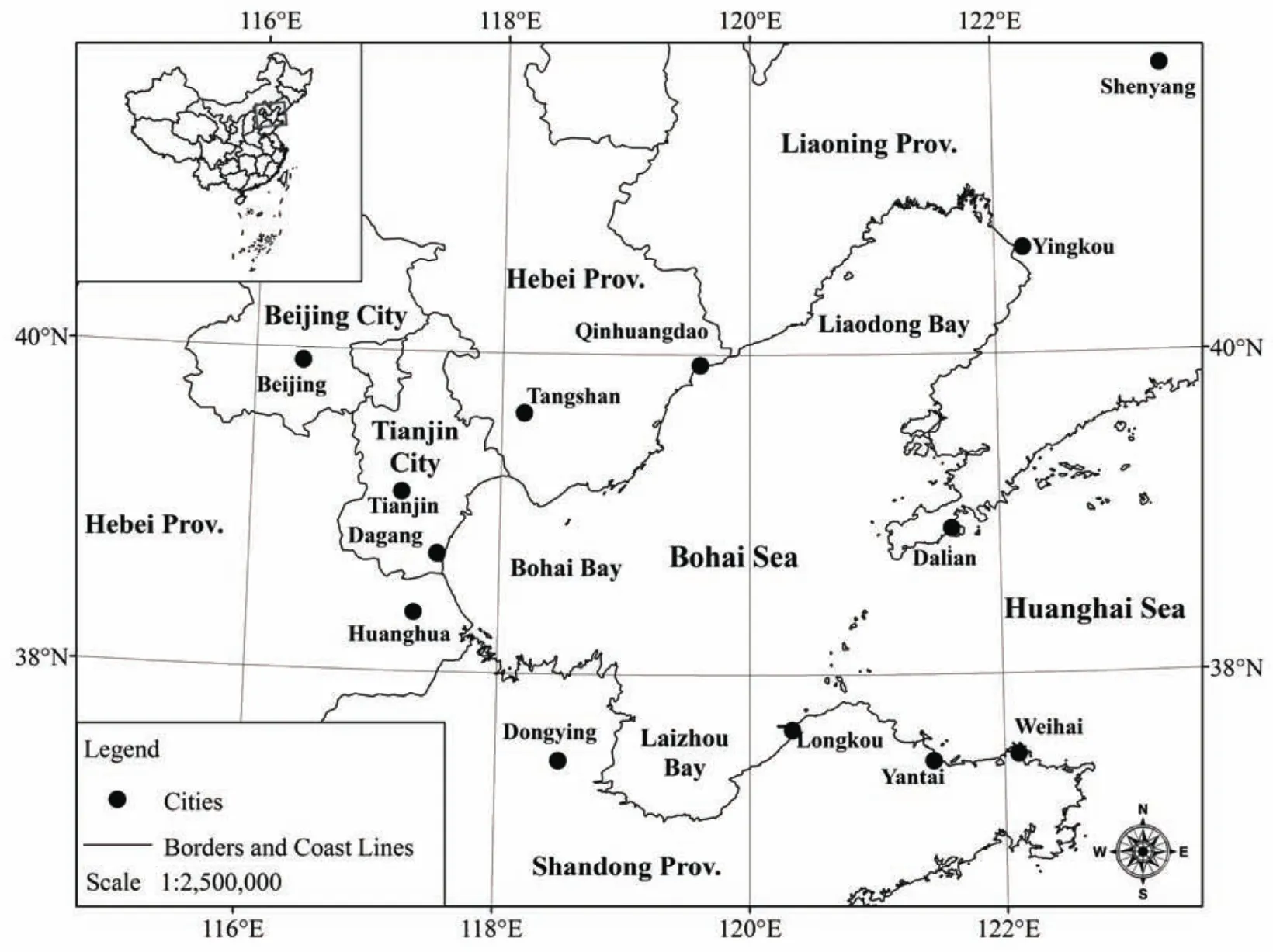
Figure 1 Bohai Sea and its coastal area
The preceding research mainly relied on data from single-point meteorological stations and short-term observations of several days. The reason is that China usually does not have weather station networks with enough spatial and temporal resolution to capture the daily variations of SLB.The main reason why Huanghua was selected as our study area is that we have a sea ice exploration experiment center owned by Beijing Normal University, which provides an ideal environment for self-setup meteorological station observations. The meteorological stations were set up with increasing distance to the coastline. The SLB was observed in both winter and summer. Analyses were made for the transition characteristics and impact areas of SLB on the coastal plain. Data analysis will mainly focus on wind direction transition, duration, wind velocity and the spatial range and variation of SLB.
2. Experimental design and background information ofstudy area
Huanghua city is located in an important "double ring"area around Bohai Sea and the area of Beijing and Tianjin and next to Dagang district of Tianjin City. It is the location of Huanghua port, the national trans-century Shenhua project, and an important part of the Bohai new district.Huanghua city is situated in the range of 38°09'N–38°39'N and 117°05'E–117°49'E. This area is a suitable location for this type of research due to its minimal human impact and preliminary urbanization. Huanghua is located in warm temperate zone and has a sub-humid climate. Its seasons are distinct, with humid, rainy summers and dry, cold winters due to influence from monsoons. The annual average temperature is 12 °C and annual precipitation is 627 mm.
Meteorological stations were setup in a line from the coast to inland in a west-east direction, including Zhao Jiapu Port (Point No.1), Shisan Dui (Point No.2), Guoyuan (Point No.3), Zhongjie Friendship Farm (Point No.4), Huanghua(Point No.5), Li Tianmu (Point No.6) and Cangzhou (Point No.7) (Figure 2). Points No.4, 5 and 7 were pre-existing meteorological stations owned by local meteorological bureaus. The other four were set up by our research group (Table 1). The observation stations are located in the coastal plain area where the terrain is low, flat and without mountain shelter. Altitudes of the stations range from 0 to 20 m, and farmland is the dominant natural landscape along the entire line of stations, 74 km in total. These conditions are very favorable to observation and research of sea-land breeze and coastal climate.
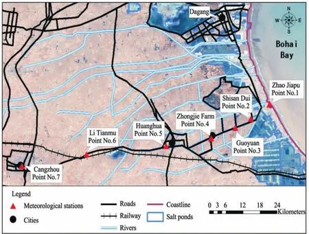
Figure 2 Distribution of meteorological observation-stations

Table 1 The status of sea-land breeze observation-stations
The meteorological instruments and observation intervals were set up in accordance with national standards. The landscape in the observation area includes farmland, villages and small towns, so the observations included wind direction and velocity not only at a height of 12 m (standard height of wind observation of meteorological station) but also at 2 m (farmland average height) and at 4 m (average height of village and town) in order to look at the impact of sea-land breeze on the local production and life in more detail. Temperature and relative humidity at 1.5 m and the land surface temperature were also included. All meteorological elements were recorded at 10 minute intervals by calibrated automatic instruments. Observations were made on November 17–December 1, 2005, January 6–January 16, 2006 and July 15–July 23, 2006. Since data from pre-existing stations were observed three to four times daily and are too sparse for a thorough analysis, this study is mainly based on the data obtained from meteorological stations set up by our group.
Figure 3 shows the daily temperature change during the observation periods. It can be seen that daily maximum temperature emerges at different times in different seasons.During observation No.1 (autumn), the average time is 14:50 coastal and 14:40 inland (Figure 3a); during observation No.2 (winter), the average time is 15:10 coastal and 13:00 inland (Figure 3b); during observation No.3 (summer),the average time is 14:10 coastal and 13:00 inland (Figure 3c). In contrast, the emergence time of daily minimum temperature changes little with varying seasons and distance to coast; and is almost the same in all regions.

Figure 3 Variation of daily mean temperature of typical stations in different observation periods
3. The definition of SLB direction and SLB day
Bohai Bay is encircled by land in an arc, so the range of land breeze direction is larger than that of sea breeze. In consideration of the distribution of stations, NE, ENE, E and ESE were the directions for sea breeze; SSE, S, SSW, SW,WSW, W, WNW, NW were the directions for land breeze,and static wind was neither sea nor land breeze. The remaining four directions that were basically parallel to the coastline were excluded.
According to standards provided by Yv (1997), the appearance and transition of daily SLB can be divided into four intervals: land breeze (0:00–7:50), transition from land breeze to sea breeze (8:00–11:50), sea breeze (12:00–19:50),and transition from sea breeze to land breeze (20:00–23:50).Data were collected at 10 minute intervals, and a total of 144 data were collected within 24 hrs.
The SLB days were determined by the apparent frequencies of sea breeze and land breeze at each four time intervals. The specific standard is as follows. The frequency of land freeze should be ≥50%, while the frequency of sea freeze should be ≤25% in the land breeze interval 0:00–7:50. The frequency of sea freeze should be≥50%, while the frequency of land freeze should be ≤25%in the sea breeze interval 12:00–19:50. Furthermore, the 24-hr land surface wind velocity should be ≤10 m/s in the selected SLB day. All standards should be met at the same time on a SLB day.
With the preceding standards of a SLB day, statistical analysis was made for those four meteorological stations on several occasions (November 11, 2005 to December 1, 2005;January 6, 2006 to January 16, 2006; July 15, 2006 to July 23, 2006). December 1, 2005; January 15, 2006 and July 22,2006 were selected as dates matching the standard conditions and treated as representative samples for the analysis of SLB characteristics on the west coast of Bohai Bay.
4. Results and discussions
4.1. The daily variations of SLB directions at the height of 12 m
The seasonal distribution of SLB is uneven; it is more frequent in autumn and winter but less in spring and summer(Yv, 1997). This is because in autumn and winter, there is considerable variation in diurnal temperature change, a crucial thermal environment for SLB development (Zhuet al.,2009). The daily occurrence of SLB can be overwhelmed by intensification of large scale background wind, which is not easily detected (Tang and Zeng, 1988; Helmis, 1995). Thus,the occurrence of a SLB day can only be observed when large scale background wind is weak. This study treated 0°as the North direction. As this angle increases, the corresponding direction changes in a counterclockwise fashion.This means 90° corresponds with West, 180° corresponds with South and 270° corresponds with East. Characteristics of Wind Direction-Time variations were obtained by plotting the observed wind direction data against time. Taking station No.6 as an example (Figure 4), on SLB days (January 15,2006 and July 22, 2006), clear transition from sea breeze to land breeze could be observed from the obvious wind direction change ranging from 90° to 180°. In contrast, on non-SLB days (January 16, 2006 and July 18, 2006), wind direction changes were relatively smaller with a range from 45° to 90°. From the observational results shown by two typical SLB days in both summer and winter, we can see that the transition between sea breeze and land breeze is more rapid in summer than in winter. The reason might be that in summer, the threshold of temperature difference between land and sea leading to SLB is easily and rapidly reached because of stronger solar radiation.
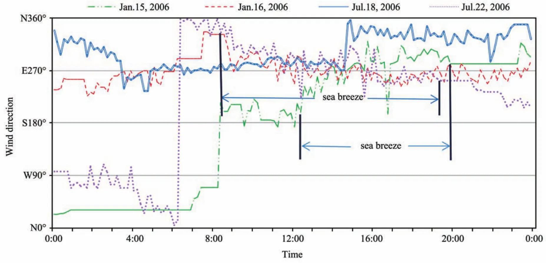
Figure 4 Comparison of wind direction change at the height of 12 m of Li Tianmu (Point No.6)
4.2. The frequencies of SLB directions at the height of 12 m
The frequencies of sea breeze directions were obtained by analyzing all the SLB days recorded from each station during the surveying period (Table 2). The sea breezes in the west coast of Bohai Bay are mainly from the ENE and E,and are basically perpendicular to the coastline. This is in accordance with results from Atkinson’s (1987) research.The frequency of sea breeze direction account for 48.33% of the total wind surveyed, ENE and E make up 66.32% of all sea breeze directions.
4.3. Durations of SLB at the height of 12 m
The duration of sea breezes varied with the station’s distance to the coastline (Table 3). The duration of sea breeze measured at point No.1 on the coastline was the longest with an average span of 10–11 hrs, and the duration of sea breeze at point No.6 was the shortest with an average span of 8 hrs.This is because sea breeze circulation develops from the coast to inland and it takes some time for this breeze to reach inland. The duration of sea breeze is also related with seasons and the starting time of the sea breeze. In summer, the sun rises early and generates stronger radiation. This enabled the necessary temperature difference between sea and inland for a SLB circulation to develop faster. Thus, the duration of sea breeze is longer and it occurs earlier, at about 8:00. In winter, the sun rises later and generates weaker radiation,thus the sea breeze appears later at about 12:00 and its duration is shorter. The duration of sea breeze in summer (July)is about two hours longer than that in winter (December and January).

Table 2 Frequency-percent of all 12 m sea breeze directions (%)

Table 3 The comparison of sea breeze duration of four stations at the height of 12 m (unit: hrs)
4.4. The variations of SLB velocity at the height of 12 m
Coastal wind velocity was significantly greater than inland wind velocity, and decreased as it moved inland. As shown in Figures 4 and 5a, on SLB days, the pattern of wind velocity at each point was similar but the wind of coastal stations was obviously stronger than that of inland stations.In winter (January 15, 2006), the sea breeze appeared later at about 12:00, and peak wind velocity appeared at about 14:00.In summer (July 22, 2006), sea breeze appeared earlier at about 8:00, with peak value occurring at about 9:00. In non-SLB days (Figure 5b), the wind change on the coast shows a similar pattern with records of two inland stations and no obvious daily peak was recorded.
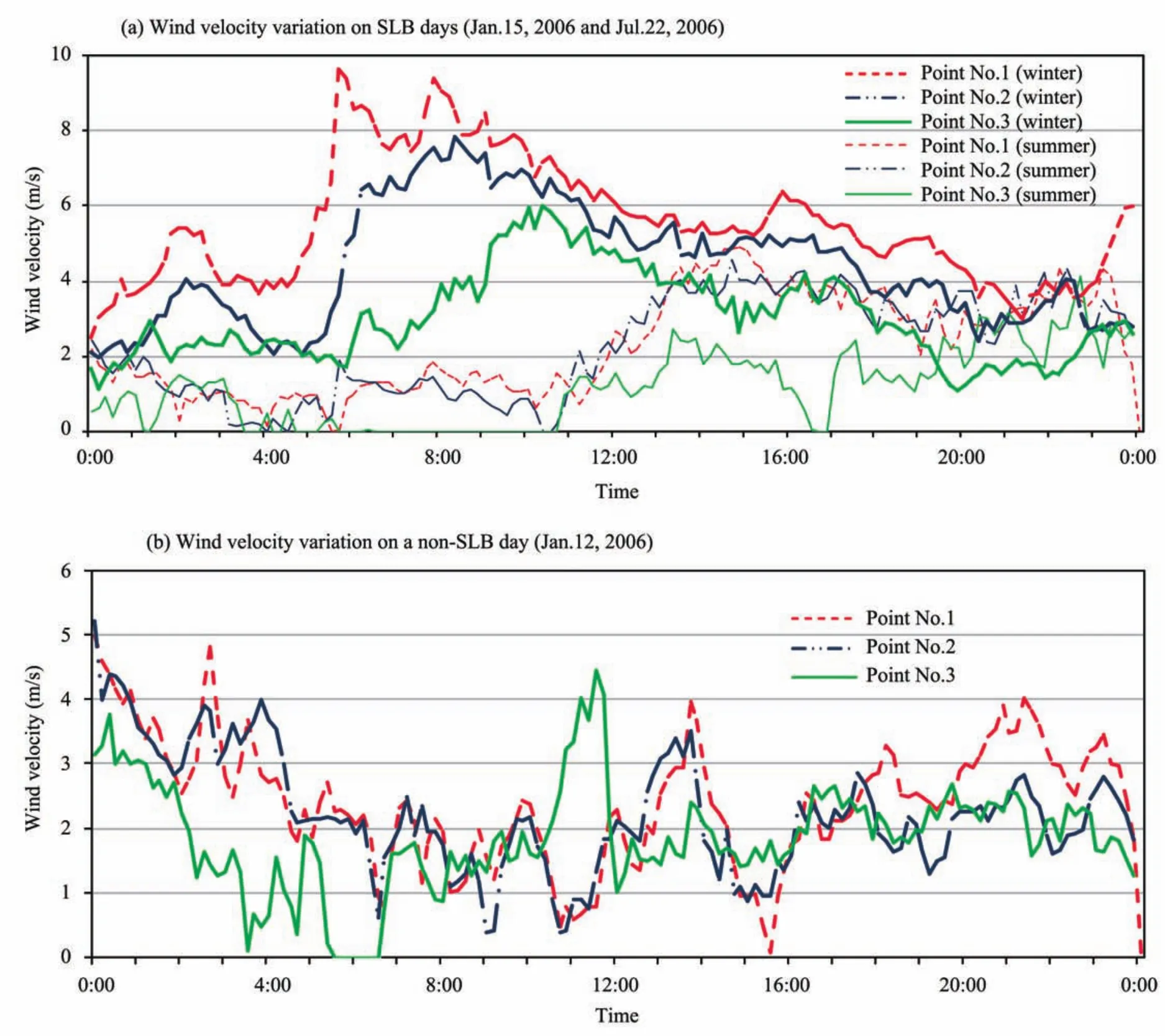
Figure 5 Wind velocity change at the height of 12 m on SLB day and non-SLB day
The absolute values of 12 m wind velocity differences of the Coast (Point No.1, 0 km to the sea), Near-Coast (Point No.2, 6.8 km to the sea) and Inland (Point No.6, 54.5 km to the sea) were calculated and plotted. On SLB days, wind velocity differences between Coast and Inland were greater than the values between Coast and Near-Coast. In winter(January 15, 2006), wind velocity differences between Coast and Inland could be as high as 4 m/s, whereas the biggest difference value between Coast and Near-coast was only 1 m/s. In summer (July 22, 2006), wind velocity differences between Coast and Inland could be as high as 8 m/s,whereas the difference value between Coast and Near-Coast was 6 m/s (Figure 6a). On non-SLB days, wind velocity difference between Coast and Inland was not as large as SLB days. More peaks (2–3) could appear in one day on non-SLB days (Figure 6b), contrasting a single-peak on SLB days.
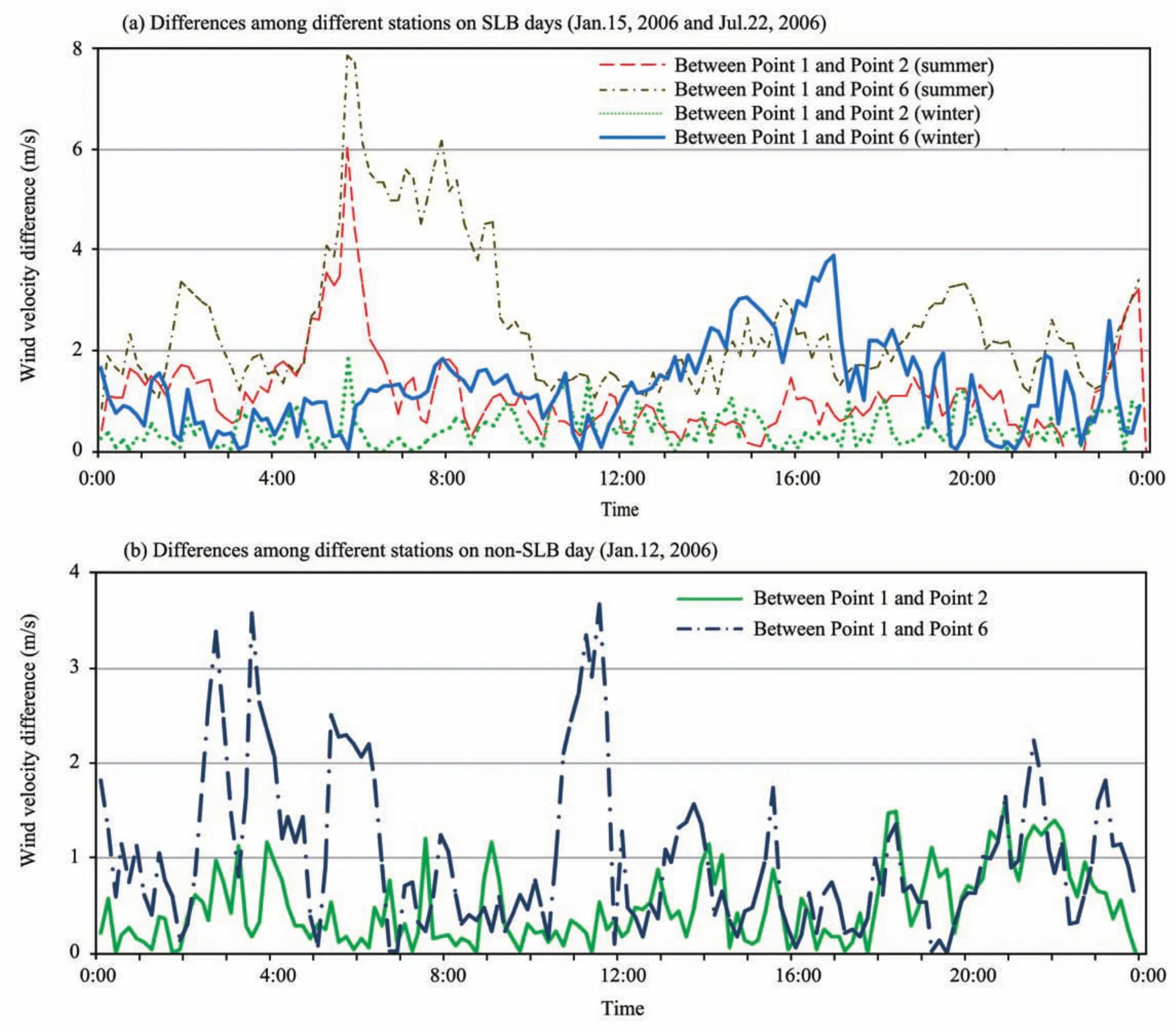
Figure 6 Absolute values of wind velocity differences at height of 12 m on SLB day and non-SLB day
4.5. Differences of SLB in sunny and cloudy days (three heights)
The thermal difference between sea and land is the cause for SLB, and the daily variation of thermal difference is not only related to seasons but also closely influenced by weather conditions. Sunny weather is favorable to SLB since increased solar radiation reaches the land surface thus producing a greater sea-land temperature difference. A cloudy day is unfavorable to SLB since solar radiation is absorbed and reflected by clouds and fogs. Solar radiation loses a large portion of its energy when it hits the land surface, so there is a smaller sea-land temperature difference.
Figure 7 shows the difference of SLB wind direction changes between a sunny and a cloudy day. It can be seen that regardless of seasons, there is a significant SLB development in sunny days (November 24, 2005 and July 22,2006) with a duration of 8 to 11 hours for sea breezes. SLB was absent in cloudy days (November 23, 2005 and July 15,2006).
4.6. Spatial extent of SLB and the concept of SLB climatic coastal zone
SLB is most obvious in coastal areas. However, as an atmospheric phenomenon, SLB impact is not only limited to near the coast since it can transport cool or warm air between sea and inland. The distance of this transportation is mainly determined by the extent of daily changes of thermal differences between sea and land.
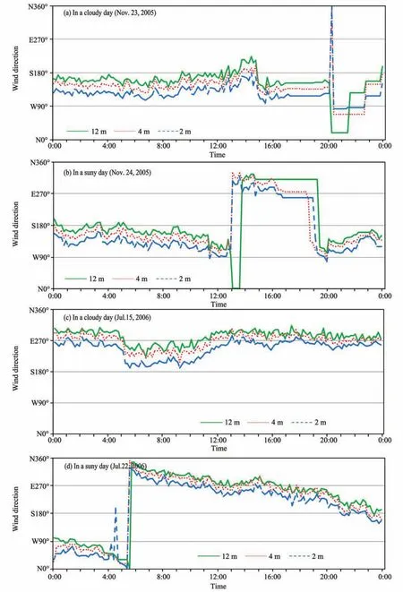
Figure 7 Wind direction change of Point No.1 at the height of 12 m, 4 m and 2 m in cloudy day and sunny day
Different disciplines have different definitions for the Coastal Zone. In oceanography, this zone is defined as water covered area near the beach, inter-tidal region and the coastal terrestrial part of the supra-littoral zone. In geography,it is considered as land assemblages spreading from the coastal baseline (Chen, 1996). In economics, it includes inland areas, coastal land, costal water bodies, offshore water and open oceans (Wu and Chen, 2001).
If we treat SLB as the criteria to define Coastal Zones,could Coastal Zone also be considered as a zone affected by SLB? If so, the boundary of SLB can be viewed as the boundary of Climatic Coastal Zone. The variation of air temperature and humidity, and the dispersion of air pollutants in such a zone should be affected to some extent by SLB.
The four stations set up in this study by our group were basically arrayed in a line from east to west, perpendicular to the coastline. The spatial distribution of SLB can be under-
stood by comparing wind direction changes of different stations on the same day. On typical SLB days (all data meets the SLB day criteria), significant wind direction changes were observed from Point No.1 on the coast to Point No.7,which is 74 km inland. Point No.7 shows obvious change of wind direction as early as 6:00 (Figure 8). On non-typical SLB days (at least two of four stations met the criteria for SLB days), significant SLB wind direction changes were only observed at coastal and near coastal stations (Figure 9).No obvious SLB wind direction change was observed at Point No.6, which is 54.5 km inland. This means that on the west coast of Bohai Bay, the sea breeze can reach as much as 74 km inland on a typical SLB day. Our results agree with the ARPS mode model by Youet al.(2006), which shows that SLB can reach about 100 km inland to Beijing and Tianjin area. On non-typical SLB days, SLB can only reach less than 10 km inland.
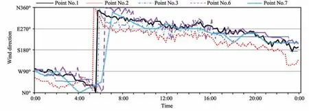
Figure 8 Spatial pattern of wind direction at the height of 12 m on a typical SLB day (July 22, 2006)
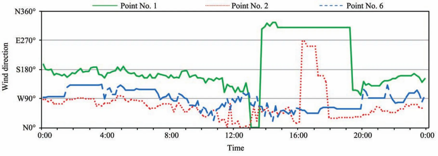
Figure 9 Spatial pattern of wind direction at the height of 12 m on a non-typical SLB day (November 24, 2005)
Table 4 shows the spatial variation of daily average wind velocity on a typical SLB day, which decreases as it moves from the coast inland. The spatial decreasing ratio for summer is 0.023 m/(s·km), and the value for winter is 0.018 m/(s·km).
5. Conclusions
On typical SLB days, the transition from sea breeze to land breeze was significant with wind direction changing from 90° to 180°, whereas on non-typical SLB days the change was smaller (within 45° to 90°). The transition of SLB was rapid in the summer but needed more time in the winter.
The sea breeze on the west coast of Bohai Bay was mainly from two wind directions (ENE and E), which were practically perpendicular with the coastline. The frequency of sea breeze direction accounted for 48.33% of the total wind directions surveyed. ENE and E together accounted for 66.32% of all sea breeze directions.
The duration of sea breeze varied in terms of stations’distance to the coast. Sea breeze on the coast lasted the longest, with an average span from 10 to 11 hours. Inland sea breeze was the shortest with an average span of eight hours.Sea breeze circulation in summer began earlier than in winter, and the duration of sea breeze in summer was two hours longer than that in winter.
Wind velocity on the coast was much greater than inland,and it gradually decreased as it moved inland. On an SLB day, there was an obvious peak value in the daily variation of wind velocity; but on a non-SLB day, no such peak value existed. The difference of wind velocity between the coast and inland in summer was greater than that in winter.
Whether in winter or summer, SLB developed significantly in sunny days with a sea breeze span of 8–11 hours,while no obvious SLB developed in cloudy days.

Table 4 Comparison of wind velocity at 12 m on typical SLB day
The impact area of SLB could be viewed as a "Coastal Meteorological Zone". On the west coast of Bohai Bay, on a typical SLB day the sea breeze could reach as much as 74 km inland, but on a non-typical SLB day, SLB could only reach less than 10 km inland.
The observation period of this research was short, thus one of the deficiencies of the research was the limited amount of data collected, as they may not completely represent the local SLB climate. However, as directly-obtained field observation data, it can be judged as a primary test for characteristics of daily SLB on the west coast of Bohai Bay in different seasons (winter and summer). This study focused on characteristics of wind direction and wind velocity during different observation times. Other important variables such as temperature, humidity as well as their relationships with SLB will be studied in the future.
This work was supported by National Science & Technology Support Key Project of China (No.2006BAB03A03),National 863 Key Project of China (No.2006AA100206)and National Natural Science Foundation Projects of China(No.40801230 and No.40335048). The authors express their appreciation to the individuals in the working group for their help during field observations, and to the anonymous reviewer for helpful comments and suggestions.
Atkinson BW, 1987. Meso scale atmospheric circulation. China Meteorological Press, Beijing, China. Translated by Meso-scale atmospheric circulation translation group.
Chen SP, 1996. Coastal Zone and its sustainable development. Remote Sensing Information, 3: 6–12.
Ding AJ, Wang T, Zhao M, Wang TJ, Li ZK, 2004. Simulation of sea-land breezes and a discussion of their implications on the transport of air pollution during a multi-day ozone episode in the Pearl River Delta of China.Atmospheric Environment, 38: 6737–6750.
Fisher EL, 1960. An observational study of the sea breeze. Journal of the Atmospheric Science, 17: 645–660.
Helmis CG, Papadopoulos KH, Kalogiros JA, Soilemes AT, Asimakopoulos DN, 1995. Influence of background flow on evolution of Saronic Gulf sea breeze. Atmospheric Environment, 29: 3689–3701.
Kingsmill DE, 1995. Convection initiation associated with a sea-breeze front,a gust front and their collision. Monthly Weather Review, 123(10):2913–2933.
Kong NQ, Ou ZF, 1998. The characteristic analysis of sea-land breeze in Beihai. Journal of Guangxi Meteorology, 19(2): 33–35.
Melas D, Ziomas I, Klemn O, Zerefos CS, 1998. Anatomy of the sea-breeze circulation in Athens area under weak large-scale ambient winds. Atmospheric Environment, 32(12): 2223–2237.
Shi PJ, Ha S, Yuan Y, Zhou JH, Xie F, 2002. The desalinization of Bohai sea ice and its use value as fresh water resource. Journal of Natural Resources, 17(3): 353–359.
Skakalova TS, Savov PB, Grigotov IV, Kolev IN, 2003. Lidar observation of breeze structure during the transition periods at the Southern Bulgarian Black Sea coast. Atmospheric Environment, 37: 299–311.
Srinivas CV, Venkatesan R, Bagavath SA, 2007. Sensitivity of mesoscale simulations of land–sea breeze to boundary layer turbulence parameterization. Atmospheric Environment, 41: 2534–2548.
Tang YH, Zeng XZ, 1988. Atmospheric Environmental Science. Zhongshan University Press, Guangzhou, China.
Turbulence and dispersion research group of Peking University (TDRGPU),1979. Sea breeze on the coastal areas of Western-Jinzhou. Symposium of geophysics department in Peking University, 31–44.
Wu XL, Chen HJ, 2001. The experience of the integrated coastal zone management in the USA. City Planning Review, 25(4): 26–31.
Xu YJ, Gu W, Chen WB, Xu XR, Zhang GM, Shi PJ, Li N, Cui WJ, 2007.Influence of posture of desalination of sea ice in solid state by gravitation.Marine Environmental Science, 26(1): 28–32.
You CH, Cai XH, Song Y, Guo H, 2006. Local atmospheric circulations over Beijing-Tianjin area in summer. Acta Scientiarum Naturalium Universitatis Pekinensis, 42(6): 779–783.
Yv EH, 1997. Sea-land Breeze and Its Application. Meteorology Press,Beijing, China.
Zhou QK, 1987. The research of Sea-land breeze circulation characteristics on the coastal area of Zhejiang Province. Journal of Hangzhou University Natural Science Edition, 14(1): 109–119.
Zhu BZ, 1955. Sea-land breeze in Taiwan. Monthly Journal of Climate(Supplement), 8: 1–5.
Zhu LY, Xu YJ, Cui WJ, Gu W, Huang SQ, 2009. The observation research of temperature impacted by the sea land breeze in the coastal area of Western Bohai bay. Scienca Meteorologica Sinaca, 29(5): 694–699.
10.3724/SP.J.1226.2011.00264
*Correspondence to: Dr. Ning Li, Academy of Disaster Reduction and Emergency Management, Beijing Normal University, Beijing 100875, China. Tel: +86-10-58809998; Fax: +86-10-58809998; Email: ningli@ires.cn, weigu@bnu.edu.cn
24 November 2010 Accepted: 15 March 2011
 Sciences in Cold and Arid Regions2011年3期
- Sciences in Cold and Arid Regions的其它文章
- Will Glacier No.1 Tianshan exist in the 22nd century?
- Sensitivity of mountain runoff to climate change for Urumqi and Kaidu rivers originating from the Tianshan Mountains
- Effects of grazing and climate change on sandy grassland ecosystems in Inner Mongolia
- Temporal variations in aerosol composition at Lanzhou City, Northwestern China
- Hydrological and climatological glaciers observation 20 years on Tanggula Pass of Tibetan Plateau: its significance and contribution
- Concentration of trace elements and their sources in a snow pit from Yuzhu Peak, north-east Qinghai-Tibetan Plateau
