Hydrological and climatological glaciers observation 20 years on Tanggula Pass of Tibetan Plateau: its significance and contribution
TanDong Yao , YinSheng Zhang *, JianChen Pu , LiDe Tian , Yutaka. Ageta , T. Ohata
1. Institute of Tibetan Plateau Research, Chinese Academy of Sciences, Beijing 100085, China 2. Cold and Arid Regions Environmental and Engineering Research Institute, Chinese Academy of Sciences, Lanzhou, Gansu 730000, China 3. Japan Agency for Marine-Earth Science and Technology Research Institute for Global Change, Yokosuka, Japan 4. Nagoya University, Nagoya,464-8601, Japan
Hydrological and climatological glaciers observation 20 years on Tanggula Pass of Tibetan Plateau: its significance and contribution
TanDong Yao1, YinSheng Zhang1*, JianChen Pu2, LiDe Tian1, Yutaka. Ageta4, T. Ohata3
1. Institute of Tibetan Plateau Research, Chinese Academy of Sciences, Beijing 100085, China 2. Cold and Arid Regions Environmental and Engineering Research Institute, Chinese Academy of Sciences, Lanzhou, Gansu 730000, China 3. Japan Agency for Marine-Earth Science and Technology Research Institute for Global Change, Yokosuka, Japan 4. Nagoya University, Nagoya,464-8601, Japan
Two decades have passed since China and Japan jointly launched hydrological & climatological observations on the glaciers in Tanggula Pass, Tibetan Plateau. Although the research institutions involved have been either restructured or renamed, their work,between 1989 and 1993, was ground-breaking and remains significant even to this day. Some observation sites established at that time are still utilized for large-scaled projects sponsored by GAME/Tibet, NSFC (Natural Science Foundation of China) and the Major State Basic Research Development Program of China (973 Program). Recently, a glacier monitoring system has been established on the cap of Dongkemadi Glacier, and is expected to make further contributions to research on the change of the cryospheric and climatic environment in the area.
Tibetan Plateau; observation; glacier; climatic environment
1. Introduction
As a watershed between the Yangtze and Nu rivers, the 5,231-meter high Tanggula Pass is located in the center of the Tibetan Plateau, and divides it into Qinghai Province and the Tibet Autonomous Region. The railway and highway that reaches the peak has the highest elevation in the world.In terms of climatology, Tanggula Mountain is the second barrier protecting the inland from the southwest monsoons,and is a crucial climate demarcation line. South of this demarcation line, the southwest monsoons play a major role in vapor transport. However, on the north side, continental air mass is the major influence on vapor transport. Therefore, it is important to conduct hydrological and climatological observations on the glaciers at Tanggula Pass.
2. History
In 1989, an observation program focusing on glacier and climatic change was initiated by the Lanzhou Institute of Glaciology and Cryopedology, Chinese Academy of Sciences (CAS) and the Hydrosphere Research Institute Nagoya University in Japan. This program came in the wake of the China-Japan Tianshan Mountains and west Kunlun Mountains glacier observations. With the passage of time,the institutes engaged in this program have been either restructured or renamed. Nevertheless, the observations and studies initiated by them are still in progress today.
The 1989 program had over 50 participants. TanDong Yao, from Lanzhou Institute of Glaciology and Cryopedology, CAS (currently as academician member of CAS,working in Tibetan Plateau Institute), and Professor Yutaka Ageta, from Hydrosphere Research Institute under Nagoya University (now an honorary professor in Nagoya University), were leaders, on behalf of the two parties respectively.The observations were done in two stages, the first one lasting from May till early June and the second from late August to late September. The route began at Golmud and then went west by way of Xidatan, Kunlun Pass, Wudaoliang, the Tuotuo River, Tanggula Pass, Amdo, Nakchu and Lhasa, moved toward the southeast through Nyingchi,until finally arriving at the famous maritime glacier in southeast Tibet-Zepu Glacier. During the first stage, three positioning and half-positioning observation stations were set up in Xidatan, Tanggula Pass and Zepu Glacier. Of them, the one in Tanggula Pass, remains well-known for its vital geographic location, long history and the large number of the projects that have taken place there (Yaoet al.,1994).
The observation at Tanggula Pass focused on the 50.96 km2Dongkemadi River Basin, which lies in the backland of the Tibetan Plateau over the mid part of Tanggula Mountain(92°04′E, 33°05′N) and is a cold mountain area of high elevation typical of the Yangtze River source. The Dongkemadi River source has produced the Dongkemadi Glacier of 16.40 km2. It is a composite glacier formed by the convergence of a trunk glacier stretching southward and a tributary glacier extending toward the southwest. The trunk glacier covers an area of 14.63 km2, with a length of 5.4 km, a terminal altitude of 5,275 m, a snow line altitude of 5,600 m and has a mild surface. The tributary glacier, east of the trunk, is 1.77 km2, 2.8 km long and 5,926 m high at the peak,with an average snow line altitude of 5,620 m and also, a gentle and clean surface without surfacial erosion and stains(Figure 1). The drainage basin has only cold and warm seasons, void of any interims in between. During the cold seasons, the days are cold, sunny, dry and windy under the influence of the west wind circulation, often lasting as long as eight months (from October to May). During the warm seasons, the days are warm and humid under the effects of wet-warm airflow from the India Ocean, usually lasting only four months (from June till September). The annual average temperature is -6.0 °C and the annual temperature scope is 24.9 °C. The temperature rises above 0 °C only between June and September. The annual relative humidity is 65%,with rainfall occurring mainly between June and September(Pu and Yao, 2002).
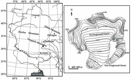
Figure 1 Location of observation sites in Dongkemadi Basin
This investigation sought to reveal characteristics of the regional climatic environment and its variation trend through research on ice cores and ice-snow chemical environment, to expound glacier variation traits and spatial differentials among glaciers on the Tibetan Plateau via study on glacier mass balance and variation, and to bring to light the correlations between cryosphere, hydrosphere and atmosphere by means of exploring the climate and the hydrologic process over glacier area. Compared with former studies of the same kind, this study was characterized for its emphasis on measurements from ice cores and the chemical environment in the ice and snow. Given this emphasis, the correlations between the stable isotopes in rainfall, temperature, and vapor source were a particular focus, which is revolutionary for the whole field of glaciology. Also within this program, glacier mass balance in the backland of the plateau was systematically studied for the first time and new findings were made on glacier variation in both climatological and hydrological terms (for more details see Yao and Ageta, 1993).
This investigation successfully drilled two ice core samples from the surface of Dongkemadi Glacier at altitudes of 5,700 m and 5,800 m, with sampling depths of 17 m and 14 m (Houet al., 1996; Shenget al., 1996), respectively. While this may be common practice today, it was quite ground-breaking at the time on the Tibetan Plateau and pushed the study of climatic environment, ice core and snow-ice chemical environment in China to new heights.Additionally, the mass balance observation system established for Dongkemadi Glacier has become an exclusive observation site permanently in use on the Tibetan Plateau and the second of such sites in China. Finally, research on the microclimate and hydrological process performed in 1989 contributed significantly to the settlement of basic observation longitude and latitude, the three space-time scales and the four key points (Ohataet al., 1991) listed below.
(1) Three space-time scales: 1) 100km scale: Dongkemadi Basin, close observation in summer; 2) 101km scale:Tanggula Pass, yearly successive observation (through automatic monitoring site); 3) 102km scale: permafrost between Wudaoliang and Nakchu through consignment sampling.
(2) Four key points: 1) variation of snow accumulation and its influence on the commutation of surface water and heat; 2) radiation feedback between snow pack and clouds; 3)hydrological characteristics of permafrost; 4) evaporation/sublimation of snow/ice.
The second tide of glacier study at Tanggula Pass came in 1993 with a focus placed on intensive observation. Between April and November of that year, utilizing the observation system established in 1989, a staff of 100 individuals from China and Japan carried out comprehensive and tridimensional climatic-hydrological observations over the Dongkemadi Basin (Agetaet al., 1991). Key objects observed and studied included terrain processes, troposphere climatic process, precipitation meteorology and hydrology near ground layer. In addition, climatic environment features and their variation trends, glacier variation traits as well as microclimate and hydrological process of glaciers were included. Below are listed the key points sorted out in this observation:
(1) To make clear the role that cryospheric change plays in the seasonal changes of hydrological circulation factors,which include variations in rainfall, evaporation, runoff and soil moisture, and expound variation trends and the correlations in between.
(2) To study the atmosphere of the Tibetan Plateau, particularly the role that the atmospheric boundary layer plays in the interaction between atmosphere and ground surface.
(3) To study the application of satellite data (including the use of visible light, infrared ray and Microwave Remote Sensors) in revealing climatic environment characteristics and its variation trend on the Tibetan Plateau.
(4) To explore the information reflected by cryospheric and climatic changes in response to global warming on the Tibetan Plateau.
The observation and recording was performed automatically, with the aid of manual measurements, for the majority of this study, which was the first incidence of automatic work on a large space-time scale in China. Descriptions of the hydrological observations are shown in Table 1. Conductivity and climatic factors were automatically recorded by instruments with a time interval of 1 hour. Data on runoff was acquired through the calculations of hydrological materials. Rainfall and soil evaporation were measured manually, with "day" being the unit of time. Table 2 includes a description of the details about the automatic weather stations, whose observation objects include: temperature, moisture, atmospheric pressure, ground temperature, air speed,wind direction, and solar radiation. In addition, close observations of rainfall, ground temperature, soil moisture and permafrost active layers were conducted at the following locations: highway No.105 maintenance spot (D105), Tanggula Pass (TP) and highway No.100 and No.103 maintenance spot(D103 and D100). Soil-evaporation observation spots for lands of different topographic features and the comparative observation of Tretyakov rain gauge were set up near the investigation camps.
This large-scale observation turned out to be fruitful. It yielded dozens of journal papers, a data set jointly published by China and Japan (Ohta and Ageta, 1996), a special issue of Bulletin of Glacier Research Publication (Agetaet al.,1994), a monograph (Yao, 2002), and perhaps most significant, an observation system was developed, modified and utilized for projects sponsored by GAME/Tibet, NSFC and 973 Program. New hydrological stations have since been established utilizing this system.

Table 1 Description of hydrological observation
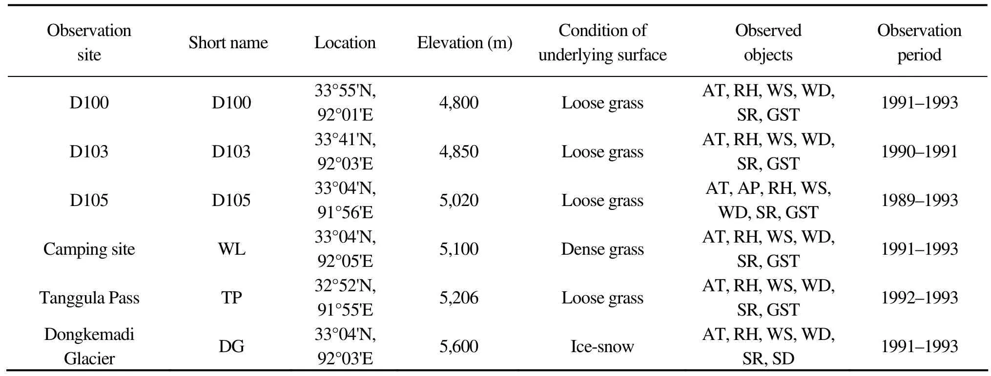
Table 2 Description of Automatic weather stations
3. A brief introduction of two decades of research results
3.1. The Tibetan Plateau and global warming
On the Tibetan Plateau, the interaction and interdependency between cryosphere, atmosphere and hydrosphere form a climatic complex, whose condition is closely related to both plateau traits and the vapor transportation process. In this process, the atmosphere plays the primary role with the cryosphere and hydrosphere in supporting roles.
Evidence demonstrates an atmospheric influence on glacier mass balance. In the summer, heat island effects speed up current exchange, which ultimately results in showers.Unlike weather processes on a larger scale, this kind of shower is usually too short to bring snowfalls heavy enough to obstruct glacier flow. As a result, glaciers continue to melt substantially even in the summer during snowy weather.Given this phenomenon, snow melting dominates the mid-summer while snow accumulation plays a major role(Puet al., 2008) in the mass balance of a glacier.
Referred to as a water tower of the world, the Tibetan Plateau has a huge effect on global water circulation (Xuet al., 2008). It is through the transportation of air mass that the atmosphere influences the cryosphere and hydrosphere.Since 1989, the isotope analysis centered at Tanggula Pass demonstrated that there is a significant climatic division on the plateau, where on the south vapor is mainly transported by the southwest monsoons and on the north vapor is transported by the continental air mass. Obviously, the effect produced by maritime air mass on the cryosphere and hydrosphere is far from that by continental air mass. During the summer monsoon period, many similarities have been found on frequency and daily variation of rainfall between the two sides, however differences of up to 50% can be seen between the two sides (Yanget al., 2007), implying a discrepancy even more striking in glacier accumulation.
3.2. Research on chemical conditions in ice and snow
The research on chemical conditions in ice and snow conducted in the vicinity of Tanggula Pass included a study on ice cores and an analysis of rainfall isotopes. The former study revealed how the climatic environment varied throughout history and the latter study explored the process of vapor transportation and circulation, providing a theoretical basis for the initial study. In May 1989, as mentioned above, for the first time researchers studied the two ice cores which were obtained from the surface of Dongkemadi Glacier. The analysis of δ18O in the 14 m ice core assisted in determining the time series of the glacier for the 45 years.Included in the series, were four cool-downs, spanning the years from 1944–1947, 1952–1954, 1969–1973 and 1979–1982, and four warm-ups from 1948–1951,1955–1968, 1974–1978 and 1983–2002. In addition, according to the data retrieved from the fixed time series, there were also four dry spells and four wet spells, in 1944–1948,1952–1962, 1976–1978, 1982–1987 and 1949–1951,1963–1975, 1979–1981, 1987–2002, respectively. Furthermore, temperature and rainfall changes recorded by the ice cores were found to be synchronous, with high temperatures corresponding to strong rainfall andvise versa. Nevertheless,the periods of change proved to be uneven.
The observation of a fixed space-time scale is indispensable in the analysis of isotopes in modern rainfall, and thus the vital observation site on Tanggula Pass, in the Tibetan Plateau has made an essential contribution to the evaluation of environmental changes in China. As early as the first investigation in 1989, TanDong Yao and his group identified seasonal variation of the atmospheric circulation over the pass (Yao and Ageta, 1993). Based on this information, they defined the advance and retreat of the southern Asian monsoons on the plateau through an analysis of δ18O in a snow samples from Dongkemadi River valley.
Grounded in the research above, Lanzhou Institute of Glaciology and Cryopedology, CAS (today’s Cold and Arid Regions Environmental and Engineering Research Institute,CAS) has selected ten observation sites for sampling from north of the plateau to the south to study the variation of δ18O in hydrological processes. Long years of extensive monitoring have explicitly demonstrated that the variation of stable isotopes in rainfall is affected by temperature. In the northern part, the relationship between stable isotopes in rainfall (δ18O) and temperature variation can be quantitatively represented, every 1 °C variation in the latter leads to a 0.65‰ change in the former. In the south, δ18O variation is affected by precipitation, reflecting the influence of the southwest monsoons, nevertheless, it is still subject to temperature effect on a large time scale. In short, the study not only produced new findings about the recent climatic variation of the plateau, but also laid a solid foundation for the decoding of ice core records.
3.3. Research on glacier evolvement
According to the glacier catalog in China, the Tibetan Plateau has produced 36,918 modern glaciers, with a total area of 49,903 km2and an ice reserve of 4,572 km3taking up 79.6%, 84.0% and 81.6%, respectively, on the national scale in each of the three aspects. Overall, the Tibetan Plateau is considered the largest low-latitude glacier distribution area in the world (Shi, 2005). Since the Little Ice Age, the glaciers on the plateau have been shrinking, and the rate seems to be increasing. Despite the fact that two slow-downs of the shrinkage and a subtle expansion were all witnessed in the past century, glaciers, as a whole, are decreasing, and the global warming trend that began in the 1980s is largely responsible. However, in recent years, glacier expansion has slowly increased. Conversely, since the Little Ice Age, no measurable variation is detected in the glaciers on Puruogangri, Malan Mountain and Tanggula Pass. In fact, the same can be said of the Qiangtang interior drainage area and even the whole plateau (Puet al., 2004).
Glacier variation demonstrates regional features. The variation is the broadest on the eastern and southern edges of the plateau and much narrower in the center-north hilly and the Qiangtang areas, where the shrinkage is minimal compared to that of glaciers over the Shisha Pangma Peak in the south and Hailuogou and Gongga Mountains. This implies that glaciers in the marginal mountainous areas are more sensitive to climatic variation than those in the interior region. The observation station established in 1989 on Dongkemadi Glacier has yielded a systematic series of data on mass balance, cumulative balance amount, the equilibrium line altitude, and glacier temperature and glacier cap variation. This data set is second only to the data collected from Glacier No.1, Tianshan, Urumqi, where monitoring lasted for the longest term.
Pu and Yao (2002), researchers in the 1989 program, restored the 50-yr mass balance of Dongkemadi Glacier. According to information extracted from the 14 m ice core,they determined that, between 1944 and 1993, a positive balance was seen in 33 yrs while a negative balance was seen in 17 yrs, with the cumulative balance being 5,214.4 mm and the average annual balance being 104.4 mm. This indicates that the glacier thickened by 6 m in the 50 yrs (that is, by 11–12 cm annually). However, according to the results of mass balance observation, the positive balance lasted only till 1993 (Figure 2; Puet al., 2008), with the cumulative amount between 1989 and 1993 being 970 mm, and, from 1994 on, a negative balance predominated, especially obvious in 1998, with a cumulative amount of -701 mm. The cumulative negative balance between 1993 and 2002 reached 3,000 mm. This variation trend of mass balance observed on the Dongkemadi Glacier is nearly equal to that seen on Glacier No.1, Tianshan.
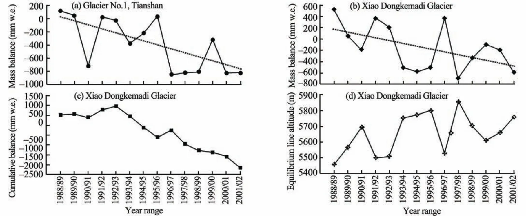
Figure 2 Annual variations of mass balance and its trend observed in Glacier No.1, Tianshan (a), annual variations of mass balance and its trend (b), cumulative balance amount (c), and the equilibrium line altitude (d) observed in the Xiao Dongkemadi Glacier,central Tibetan Plateau (Pu et al., 2008). w.e. in unit means water equivalent.
The average altitude of the zero balance line on the Dongkemadi Glacier is 5,600 m. This includes an increase of 400 m seen between 1989 and 2002. Zhanget al. (1998)explored the sensitivity of altitude to climatic variation by establishing the variations modes. According to their findings, the sensitivity coefficients of zero-balance-line altitude of the Dongkemadi Glacier to temperature, rainfall, and net radiation were 58.2 m/K, 38.0 m/(100mm) and 55.2 m·MJ/(m2·d), respectively. Those of Glacier No.1, Tianshan are 85.8 m/K, 29.0 m/(100mm) and 44.5 m·MJ/(m2·d), respectively. It is clear that the zero-balance-line altitude of the Dongkemadi Glacier is more sensitive to rainfall variation.This can be explained by the fact that the mass balance of glaciers at such high altitudes is susceptible to surface sublimation and that sublimation at the zero-balance-line altitude of the Dongkemadi Glacier accounts for almost a quarter of the melting (Zhanget al., 1996a). This is why glacier mass balance is in a closer relation with rainfall than with temperature.
3.4. Research on climatic process
In 1989, the first automatic weather station was set up at an altitude of 5,020 m over the Dongkemadi Basin in the China-Japan joint program. By 1993, the number of automatic weather stations on the plateau had increased to six,with their elevations ranging from 4,800 m to 5,600 m, and with one located on the glacier surface. Data recorded at the weather stations includes atmospheric temperature, moisture,air pressure, wind speed, rainfall, solar radiation and soil temperature. The most remarkable contribution made by these stations was the acquisition of climatic process’s chronological sequence of the area. Due to the limitation of objective conditions, climatic data in cold and high areas was not regularly available. The observations on the different underlying surfaces in the Dongkemadi Basin have updated people’s knowledge about climatic change in high and cold areas.
The ability to collect consistent data has increased available data about seasonal variation of the climatic process in glaciers and permafrost surface in a more comprehensive way. Apart from some of the observation objects listed above (air temperature, moisture, air pressure, wind speed and rainfall), the characteristics of surface energy exchange over cold-high areas have also been recorded. The observation results yielded by the automatic station on the Dongkemadi Glacier, located at an altitude of 5,600 m close to the zero-balance line, can represent the average state of energy exchange in the whole glacier area, which is an important contribution. In the past, observations were limited by inclement conditions, and could only be carried out over melting areas. Thus, results could only reveal data about energy exchange in the melting areas, rather than the whole glacier.
Radiation balance observation results indicate that the net radiation on the glacier surface is negative for approximately half of the year (November to March). This demonstrates that for almost six months annually, energy consumed in the form of radiation is replaced by turbulent exchange on the glacier surface. This is in contrast to net radiation measurements, defined as the value of heat exchange through which energy is fed to the glacier surface, which is positive throughout the year in a bimodal seasonal variation. Similar to that seen in non-glacier areas, net radiation peak values result from solar radiation through atmospheric inversion layers. In the summer, it is caused by the atmospheric inversion layers that are formed by the stable 0 °C layer near the ground and the upper layer that exchange as the temperature increases. This is unique to the glacier surface.
Consistent observations, over many years, from the glacier surface’s energy balance have also broken new ground in the quantitative study of the role of sublimation in the mass balance. Glaciers in China are continental and distributed over the western region, which is characterized by high temperatures and little rainfall in summer. Researchers believe, in continental glaciers, both accumulation and melting of glaciers takes place in summers at a low level of material exchange, and apart from this, obvious sublimation on the surface of glaciers results from the arid climatic conditions.According to observation results, energy evaporation accounts for 20% of melting near the zero-balance line on Dongkemadi Glacier. It is well known that the latent heat of vaporization is six times that seen with melting. According to this view, the sublimation of 20% melting (150 mm water equivalent) is equal to a six-fold decrease in melting. When moisture falls, the patent heat will rise, which will further decrease the total melting. Taking into account all these facts,Zhanget al.(1996b) developed the ME coefficient, which is the ratio between the heat consumption and the patent heat of glacier melting. This parameter can be used to classify melting processes. When the ME coefficient is <2.0, evaporation takes up more than 1/3 of the total energy consumption and the melting is classified as evaporation. When the ME coefficient is >5.5, evaporation plays only a small part and the melting is classified as thawing.
3.5. Research on hydrological process
In the research on hydrological process of the Dongkemadi Glacier, the following components in moisture balance are included: rainfall, evaporation, moisture variation in surface soil, and runoff.
As rainfall is a fundamental factor in moisture exchange between the atmosphere and the earth’s surface, elucidating the characteristics of its space-time distribution is essential in clarifying the regional hydrological process. Rainfall in the Dongkemadi Basin at Tanggula Pass, located at the inner part of the plateau (Yao and Ageta, 1993), is much less than that in the southern part, because after a long journey, maritime air masses arriving there becomes far less influential(Yanget al., 2007). Seasonal rainfall distribution over the region is chiefly subject to plateau monsoons, which in the winter are cold anticyclone with prevailing downdrafts that cause a reduction in rainfall. Many years of observation records, from conventional weather stations in the region,show that rainfall in the summer (June–August) is 72%–76% of the annual rainfall, while that in the winter(December–January) accounts for only 0.8%–2.0%. Observations between 1989 and 1993 reveal an important relationship between central plateau convective weather and precipitation—over 90% of rainfall takes place in the warm seasons (May–September) when convective weather frequently occurs. In addition, the frequency of monthly rainfall is positively correlated with soil surface temperature(Zhang and Yao, 2002).
Ground surface evaporation was one of the key points in the 1993 investigation. Observation objects included water surface evaporation, soil evaporation, potential evaporation,ice-snow surface evaporation and evaporation from underlying surfaces. Among the techniques and methods applied were the Lysimeter, gradient contour line, moisture balancing in surface soil, and eddy covariance. The observation results of ground surface evaporation resulted in intensive study and discussion on daily and seasonal variation,space-time distribution, controlling elements and evaporation amount evaluation. Conclusions were drawn that the ground surface evaporation amount has a linear relationship with water surface evaporation and potential evaporation,and an exponential relationship with ground surface moisture content where the variability differs in line with moisture conditions. Thus, the amount of ground surface evaporation is not only determined by the variation amplitude of ground surface moisture content but also by itself. For instance, if the moisture content is 50%, a variation of 1% can result in a variation of 0.11 mm in the evaporation amount.If the moisture is 80%, the same variation amplitude can lead to a variation of 0.15 mm in the evaporation amount.The observations on daily variation demonstrated that ground surface evaporation takes place mainly between 12:00 and 20:00 local time, with a peak value around 15:00 time spot. The observation aimed at clarifying the influence of topography on evaporation found a drastic variation in evaporation amount between the lower and upper part of a slope, however, the variation is small within each region.Normally, evaporation amounts on the upper slope are the same as on the lower slope. Annual evaporation of ground surface in Tanggula region has exceeded 800 mm.
Land-surface moisture observations in the regional area focused on the correlation between the freezing-thawing process and moisture content in the soil. In soil, this process is influenced by moisture content, lithology, constituents, as well as surface conditions (Yanget al., 1999). Given the fact that water has a high thermal capacity, it releases lots of heat in the process of freezing and absorbs a lot of heat when thawing. Water content in the soil can strongly affect freezing and thawing of soil and the distribution of heat in soil(Yang and Yao, 2002). Because the processes repeat in a circulation, the water zone formed on thawing surfaces can be found to have fluctuating variations.
Between 1989 and 1993, three automatic hydrological stations were built at altitudes of 4,800 m, 5,100 m and 5,300 m, with the last two in Dongkemadi Basin where there exist 33% and 76% glacier coverage, respectively. The observations during that period focused on runoff variation on different time scales. The method of water balancing was applied to partition the observation sequence and it was concluded that the runoff modulus and ratios in glacier areas are six and two times as high as those in non-glacier areas, respectively. In other words, runoff productivity in glacier regions is greater than that in permafrost regions. Thus, researchers highlighted the role of snow-melting in moisture outputs of glaciers. The sequential observations throughout the years helped to uncover the characteristics of water balance composition in the Dongkemadi Basin where ice and snow are widely distributed across altitudes. Rainfall in glacier areas has a similar contribution (57%) to moisture input as seen in non-glacier area (43%). In moisture output,evaporation in glacier areas is 38% (sublimation plays a 6%role) and that in non-glacier area accounts for 32%, whereas runoff has a 54% share, of which 27% is formed by glacier melting. Variation of water reserves in the basin is 8% of moisture output. All these can be included in glacier mass balancing.
3.6. Research on surface process
The following advancements have been made on the surface progress in high-altitude localities through the continual observation of micro-climate and energy exchange on the ground surface:
3.6.1 The heating effect of ground surface on atmosphere
The heating effect is defined as the net energy balance between the ground surface and the atmosphere. The underlying surface is referred to as a heat source when it emits energy into the atmosphere and as a cold source when it does not. Figure 3 displays seasonal variation of the permafrost over D105 as it fluctuates between a heat source and cold source. The results show that the underlying surface of the permafrost is a heat source all year, with the exception of December. In other words, the ground surface of the region transfers heat into the atmosphere for the majority of the year. It gives off the most heat in April, as opposed to the summer when temperatures are elevated. During a short phase between November and December, energy exchange on the permafrost surface comes to a dynamic balance. Perhaps most noteworthy, is that in July, when temperatures reaches their highest, the permafrost surface has the same heat as the glacier surface and the underlying surface of the whole plateau falls into a heat balancing state. This demonstrates that horizontal exchange causes little effect on heat exchange. These observations are supported by the fact that wind speed is low on both the permafrost surface and the glacier surface in summer. For the entire year, the heat intensity of underlying permafrost is 1,817.8 MJ/(m2·yr).
Contrary to permafrost, seasonal variation between heat and cold sources of the glacier surface is much more complicated. Heat exchange balance on the surface occurs in April and between October and November. During these stages, the absolute value at low levels can represent the net input from solar radiation, the lowest levels of seasonal variation in sensible heat exchange, and a change in the direction of the volume flux in the control of patent heat exchange. So, in the study area, glacier surface is a heat source from April to November, with the maximum intensity in July and a monthly average flux volume around 60 N/m2.Between November and April, the surface acts as a cold source, with the intensity relatively high throughout the whole period, with the average monthly intensity value being 96 W/m2and the peak value arriving in January. On the whole, the glacier surface is a cold source of -159.2 MJ/(m2·yr).
3.6.2 Evaluation of energy exchange balance levels on the ground surface
Energy exchange balance on the ground surface is, in nature, the dynamic balance of energy exchange that takes place in the underlying surfaces. The exchange level—the absolute value of energy factors—varies regularly on different time scales. Zhang and Yao (2002) introduced a new concept of a "heat exchanging coefficient (Eb)" during the study of surface process in the Dongkemadi Basin, to assist in quantitatively evaluating the varied energy exchange in different underlying surfaces. The absolute value of heat input and output of a certain underlying surface (Qb) can be
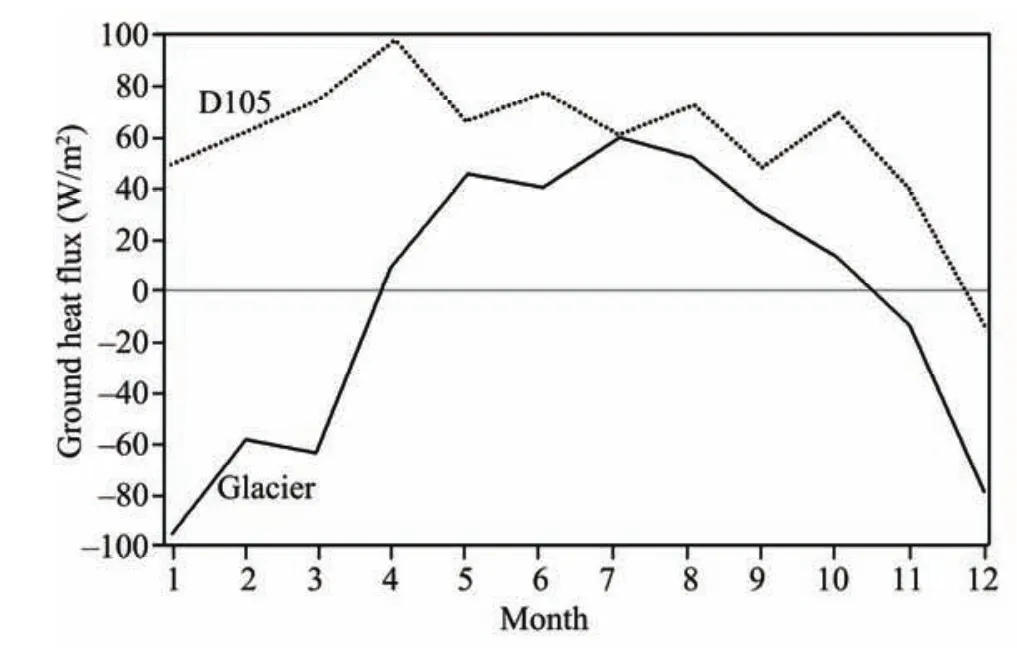
Figure 3 Seasonal variation of ground heating on Dongkemadi Glacier and D105 (Zhang and Yao, 2002)
3.6.3 Relationship between temperature and energy factor in different underlying layers
The system in the underlying surface of the glacier and the permafrost is nonadiabatic. This system needs to restructure its energy to seek a new balance when the input of taken as the flux of the total heat there, representing the energy exchanging level. As the value ofQbis quite susceptible to territoriality and seasonality, the factor of total radiation volume (Qg), which reflects territoriality and seasonality,is applied as a corrective value in the relation below:

In the relation,Eb, the heat exchanging coefficient mentioned above, is a scalar, andQbandQgare of the same unit.
Figure 4 displays the seasonal variation ofEbover D105 and the Dongkemadi Glacier. Great differences are observed with the seasonal distribution of energy exchange intensity between the two kinds of underlying surfaces. Energy exchange on glacier surfaces is intensive and stable between May and September, when much of the energy available is consumed through thawing and evaporation. However, in the period between December and January there is an intense short-term energy exchange resulting from radiation-caused loss of energy and the supplementation by other elements, with an observedEbas high as 0.58 in January.Energy exchange on the glacier surface is much lower from April to October, however energy exchange on the permafrost rises, arriving the highest level in April with anEbof approximately 0.5. Between May and September, the exchange intensity is stable as a result of ground thawing. In December, the exchange becomes the lowest, with theEbdropping near to 0.1 and the value of net radiation below zero. On the whole, the glacier surface has higher energy exchange than that seen on the permafrost surface. A large absolute value of net radiation (positive or negative) can lead to intense energy exchange.radiation energy changes. Consequently, the temperature within the system varies. Thus, temperature can be taken as a performance indicator for the inner energy of the system and a correlation can be found between temperature and energy variation. In their analysis of temperature’s effects on seasonal variation of daily net radiation on the Dongkemadi Glacier and D105 permafrost region, Zhanget al.(1996b)discovered that the peak values for temperature curve and net radiation variation do not appear simultaneously, and that the two curves are of the same trend but with different amplitudes for variation. It can be attributed to the fact that temperature responds differently to solar radiation flux within different underlying surfaces.
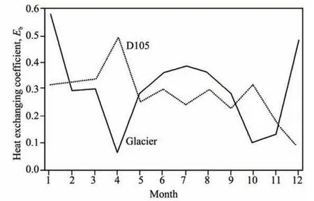
Figure 4 Seasonal variation of the "heat exchanging coefficient"(Eb) on the Dongkemadi Glacier and D105 (Zhang and Yao, 2002)
Figure 5 shows the sensitivity coefficients of temperature to radiation flux ?Ta/?Qgbetween September 1991 and September 1993. The seasonal variations of reflectivity (α) and radiation absorption fluxQg(1-α) are clearly displayed. ?Ta/?Qgdemonstrates a negative correlation withα, because it is low in the winter and high in the summer. Therefore, the same variation amplitude ofQg(1-α) leads to smaller variation amplitude of temperature on the glacier surface in winter than in summer. The variation range of ?Ta/?Qgon the Dongkemadi Glacier is 0.031–0.063 K/(W·m2), which indicates that a variation amplitude of 100 W/m2in radiation flux can only cause a variation amplitude of 0.31–0.62 °C in temperature. However, it is still likely that temperature variation plays a role in the specific timing.
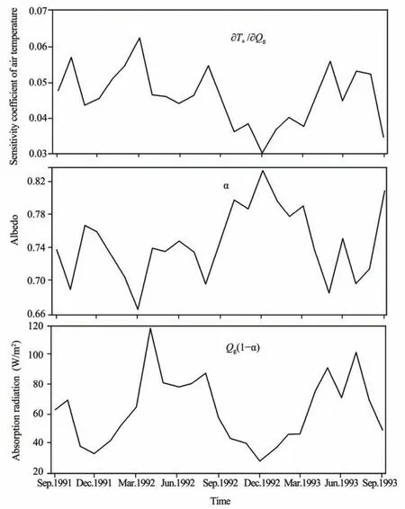
Figure 5 Seasonal variations of sensitivity coefficient of air temperature variation (?Ta /?Qg), albedo (α) and absorption radiation Qg(1-α) on the Dongkemadi Glacier (Zhang and Yao, 2002).
4. Conclusion
With important projects launched by GAME/Tibet,NSFC and the 973 Program throughout the twenty years following the 1989 investigation, significant progress has been made on climatic change research in the Tanggula region. Particularly, the study on ice-snow chemical conditions conducted with ice cores has made a remarkable contribution to elucidating the historical transitions of the climatic environment and the role the Tibetan Plateau plays in the global process of climatic change. Up to now, the pioneering role played by the 1989–1993 investigation and its results are still significant. The observation system for mass balance that was established in 1989 on Dongkemadi has been util-ized by large-scale research projects for many times from its inception. The new hydrological station recently established on the Dongkemadi Glacier will assist researchers in further investigations of water flow, alkalinity or acidity, and minerals. In addition, scientists may now collect more data and perfect a glacier monitoring system, which will in turn make significant contributions to research on both the cryosphere and the climatic environment atmosphere in the region.
This study was funded by the Major State Basic Research Development Program of China (973 Program) under Grant No.2010CB951701 and by the Natural Science Foundation of China (No.41071042), also supported by the Innovation Project of Chinese Academy of Sciences(KZCX2-YW-BR-22).
Ageta Y, Yao T, Jiao K, Pu J, Shao W, Wata S, Ohno H, Furukawa T, 1991.Glaciological studies on Qingzang Plateau, 1989 Part 2, Glaciology and geomorphology. Bulletin of Glacier Research Publication, 9: 27–32.
Ageta Y, Yao T, Ohata T, 1994. Outline of the study project on the role of snow and ice in the water cycle on Qingzang Plateau 1990–1993. Bulletin of Glacier Research Publication, 12: 87–94.
Hou SG, Qin DH, Huang CL, 1996. Preliminary study on the Ion elution of snowpacks over Qinghai-Xizang Plateau. Journal of Glaciology and Geocryology, 18(3): 227–233.
Pu JC, Yao TD, 2002. Mass Balance and Glacial Variation: Variation Features of Cryosphere in Middle Tibetan Plateau.Geological Press, Beijing.
Pu JC, Yao TD, Wang NL, 2004. Fluctuations of the glaciers on the Qinghai-Tibetan Plateau during the past century. Journal of Glaciology and Geocryology, 26(5): 517–522.
Pu JC, Yao TD, Yang MX, Tian L, Wang N, Ageta Y, Fujita K, 2008. Rapid decrease of mass balance observed in the Xiao (Lesser) Dongkemadi Glacier, in the central Tibetan Plateau. Hydrological Processes, 22:2953–2958. doi: 10.1002/hyp.6865.
Ohata T, Ageta Y, 1996. Data Report of Cryosphere Research on Qingzang Plateau, 1991–1993. Nagoya University, Institute for Hydrospheric-Atmospheric Sciences, Research Report, 2: 1–207.
Ohata T, Yasunari T, Ohta T, Ohno H, Cao Z, Ding L, Zhang Y, 1991. Glaciological studies on Qingzang Plateau, 1989 Part 3, Meteorology and hydrology. Bulletin of Glacier Research Publication, 9: 33–37.
Sheng WK, Wang NL, Pu JC, 1996. The hydrochemical characteristics in the Dongkemadi Glacier area, Tanggula Range. Journal of Glaciology and Geocryology, 18(3): 235–243.
Shi YF, 2005. Concise Glacier Inventory of China. Shanghai Popular Science Press, China. 17–32.
Xu X, Lu C, Shi X, Cao S, 2008. World water tower: An atmospheric perspective. Geophysical Research Letters, 35, L20815. doi:10.1029/2008GL035867.
Yang MX, Yao TD, 2002. Water and energy distribution in soil, freezing and thawing processes as water cycle. In: TanDong Yao. Variation Features of Cryosphere in Middle Tibetan Plateau. Geology Press, Beijing. 103–136.
Yang MX, Yao TD, Gou XH, Wang H, Hao L, 2007. Comparison analysis of the summer monsoon precipitation between northern and southern slopes of Tanggula Mountains, Qinghai–Xizang (Tibetan) Plateau: a case study in summer 1998. Hydrological Processes, 21(14): 1841–1847. doi:10.1002/hyp.6319.
Yang MX, Yao TD, Wang SL, Ding YJ, Chen XZ, Shen YP, 1999. The features of soil temperature and moisture on Northern Tibetan Plateau.Geographical Research, 18(3): 312–317.
Yao TD, 2002. Variation Features of Cryosphere in Middle Tibetan Plateau.Geology Press, Beijing. 1–308.
Yao TD, Ageta Y, 1993. Glacial Climatic and Environment of Tibetan Plateau. Science Press, Beijing. 1–147.
Yao TD, Ageta Y, Ohata T, 1994. Glaciological studies on Qingzang Plateau 1989 Part 1, Outline of the project. Bulletin of Glacier Research Publication, 9: 23–26.
Zhang YS, Fujita K, Ageta Y, Nakawo M, Yao T, Pu J, 1998. The response of glacier ELA response to climatic fluctuation on High-Asia. Bulletin of Glacier Research, 16: 1–11.
Zhang YS, Yao TD, 2002. Micro-climatology features on different surface condition area. In: TanDong Yao. Variation Features of Cryosphere in Middle Tibetan Plateau. Geology Press, Beijing. 60–102.
Zhang YS, Yao TD, Xie Z, Fujita K, 1996a. An experimental study of climate and ablation at the equilibrium line of Dongkemadi Glacier, Tanggula Mountains, Qing-zang Plateau. Zeitschrift f. Gletscherkunde und Glazialgeologie, 32: 67–74.
Zhang YS, Yao TD, Pu JC, 1996b. Energy budget at ELA on Dongkemadi Glacier in the Tanggula Mts. Tibetan Plateau. Journal of Glaciology and Geocryology, 18(1): 10–19.
10.3724/SP.J.1226.2011.00187
*Correspondence to: Dr. YinSheng Zhang, Institute of Tibetan Plateau Research, Chinese Academy of Sciences, Beijing 100085,China. Tel: +86-10-62849728; Email: yszhang@itpcas.ac.cn
22 December 2010 Accepted: 18 March 2011
 Sciences in Cold and Arid Regions2011年3期
- Sciences in Cold and Arid Regions的其它文章
- Will Glacier No.1 Tianshan exist in the 22nd century?
- Sensitivity of mountain runoff to climate change for Urumqi and Kaidu rivers originating from the Tianshan Mountains
- The research of sea-land breeze (SLB) on the west coast of Bohai Bay based on field observation
- Effects of grazing and climate change on sandy grassland ecosystems in Inner Mongolia
- Temporal variations in aerosol composition at Lanzhou City, Northwestern China
- Concentration of trace elements and their sources in a snow pit from Yuzhu Peak, north-east Qinghai-Tibetan Plateau
