Research Progress of Seafloor Pockmarks in Spatio-Temporal Distribution and Classification
XU Cuiling, XU Guoqiang, XING Junhui, SUN Zhilei,and WU Nengyou
Research Progress of Seafloor Pockmarks in Spatio-Temporal Distribution and Classification
XU Cuiling1), 2), 3), XU Guoqiang4), XING Junhui2), 3), *, SUN Zhilei1), 2),and WU Nengyou1), 2)
1),,,266071,2),,266071,3),,266100,4),,266071,
Seafloor pockmarks are important indicators of submarine methane seepages and slope instabilities. In order to promote the understanding of submarine pockmarks and their relationship with sediment instabilities and climate changes, here we summarize the research results of pockmarks in the spatio-temporal distributions and shaping factors. Most of pockmarks occur along active or passive continental margins during the last 25kyrB.P.. Circular and ellipse are the most common forms of pockmarks, whereas pockmarks in a special crescent or elongated shape are indicators of slope instabilities, and ring-shape pockmarks are endemic to the gas hydrate zones. Further researches should be focused on the trigger mechanism of climate changes based on the pockmarks in the high latitudes formed during the deglaciation periods, and the role of gas hydrates in the seafloor evolution should be elucidated. In addition, the feature of pockmarks at their early stage (., developing gas chimneys and gas driving sedimentary doming) and the relations between pockmarks and mass movements, mud diapirs could be further studied to clarify the influences of rapid methane release from submarine sediments on the atmospheric carbon contents.
pockmark; cold seep; methane seepage; gas hydrate; slump
1 Introduction and Historical Background
Seafloor pockmarks are cone-shaped depressions in softsediments that produced by the ‘blow-out’ of gas and water, which were firstly reported by King and MacLean (1970) on the Scotian Shelf by side-scanning sonar investigation, and have since been termed ‘pockmark’. The formation of pockmarks had been attributed to falling of ice-rafted boulders or human’s fishing activities on soft sediments before their association with fluid/gas escape was originally proposed by King and MacLean (1970) as a hypo- thesis. This fluid/gas escape hypothesis was manifested by Hovland. (1987) using isotopic tracer method on carbonate minerals found inside the North Sea pockmarks. In recent decades, pockmarks have been widely found both in passive and active continental margins, especially the frequent reports in the South China Sea, the west Africa Margin, the Mediterranean Sea, the North Sea and the Norwegian Sea (Fig.1; Table 1).
Seafloor pockmarks are well worth studying since they are closely related to submarine petroleum reservoirs, geo- hazard, autogenic organism and climate change. Below pockmarks, the migration pathways of gas are usually rooted in hydrocarbon resources or gas hydrate, and thus pockmarks are indicators of submarine oil or gas reservoirs. In shallow sediments below the seafloor, gas seepages may not only fracture the sedimentary layers, increasing slope instabilities, but also provide essential materials and energy for cold seep communities. Above the seafloor, methane and carbon dioxide that released from pockmarks enter the ocean water column and may even reach the atmosphere, influencing marine environment and global carbon cycle.
Nevertheless, there are still several gaps in seafloor pockmark researches. For instance, to estimate the impacts of pockmarks on slope instabilities, the shape and their shaping factors need to be further studied, since pockmarks in different shapes may have distinct impacts. Furthermore, the statistics on global spatial and temporal dis- tribution of pockmarks is lack, posing difficulties to clarify the relationship between climate change and pock- mark formations. Therefore, we summarize the latest researches on the pockmarks that relate to methane seepages in this paper, including 1) the spatio-temporal distributions of pockmarks and 2) the shape of pockmarks and their contribution factors. The aim is to promote the studies on submarine pockmarks and their relations with sediment instabilities and climate change.

Fig.1 Distribution map of global seafloor pockmark based on publications on individual regions. Numbers and selected references correspond to the Table 1.
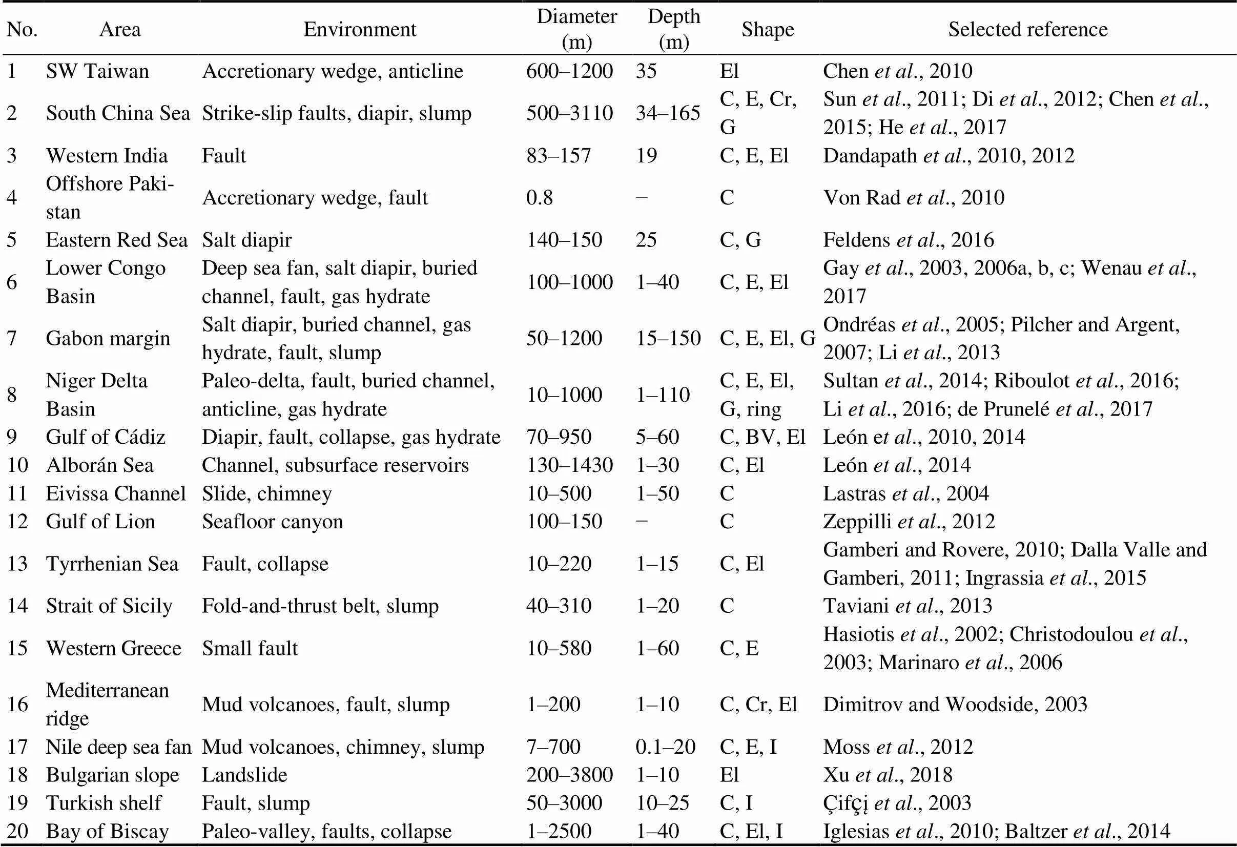
Table 1 Size, shape and geological setting of pockmarks, numbers correspond to the Fig.1 (a selection of references is also listed).
()
()
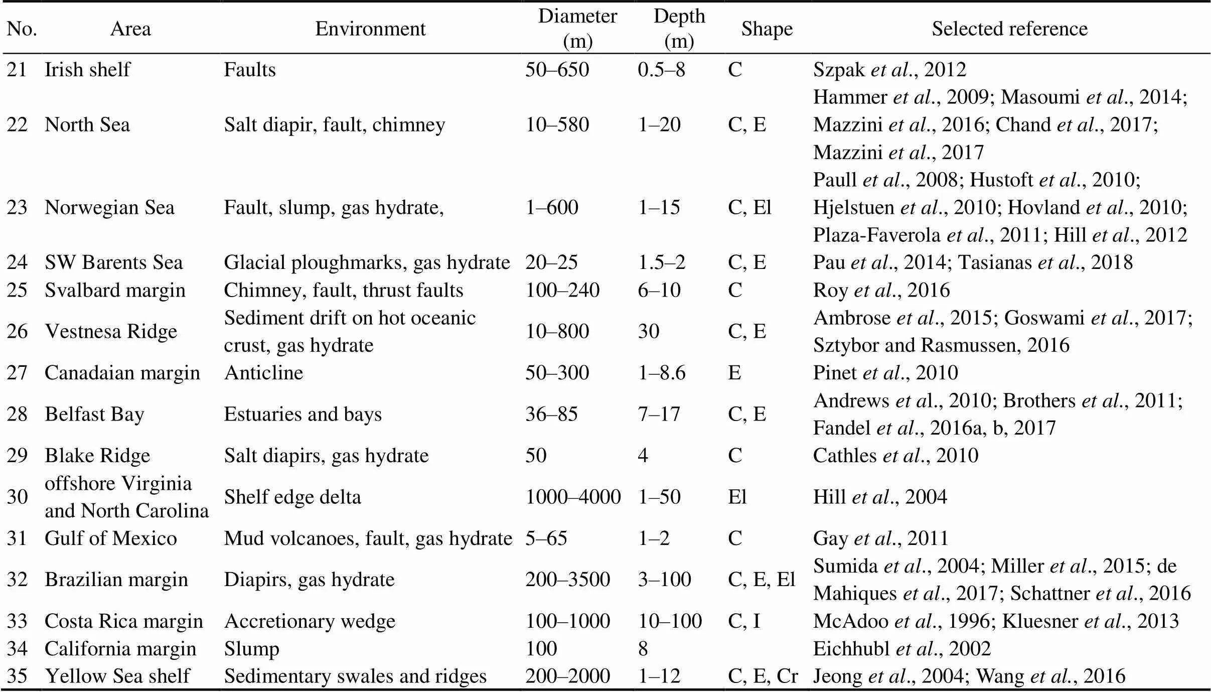
No.AreaEnvironmentDiameter (m)Depth (m)ShapeSelected reference 21Irish shelfFaults50–6500.5–8CSzpak et al., 2012 22North SeaSalt diapir, fault, chimney 10–580 1–20C, E Hammer et al., 2009; Masoumi et al., 2014; Mazzini et al., 2016; Chand et al., 2017; Mazzini et al., 2017 23Norwegian SeaFault, slump, gas hydrate,1–6001–15C, ElPaull et al., 2008; Hustoft et al., 2010; Hjelstuen et al., 2010; Hovland et al., 2010; Plaza-Faverola et al., 2011; Hill et al., 2012 24SW Barents SeaGlacial ploughmarks, gas hydrate20–251.5–2C, EPau et al., 2014; Tasianas et al., 2018 25Svalbard marginChimney, fault, thrust faults100–2406–10 CRoy et al., 2016 26Vestnesa RidgeSediment drift on hot oceanic crust, gas hydrate10–80030C, EAmbrose et al., 2015; Goswami et al., 2017; Sztybor and Rasmussen, 2016 27Canadaian marginAnticline50–3001–8.6EPinet et al., 2010 28Belfast BayEstuaries and bays36–857–17C, EAndrews et al., 2010; Brothers et al., 2011; Fandel et al., 2016a, b, 2017 29Blake RidgeSalt diapirs, gas hydrate504CCathles et al., 2010 30offshore Virginia and North CarolinaShelf edge delta1000–40001–50ElHill et al., 2004 31Gulf of MexicoMud volcanoes, fault, gas hydrate5–651–2CGay et al., 2011 32Brazilian marginDiapirs, gas hydrate200–35003–100C, E, ElSumida et al., 2004; Miller et al., 2015; de Mahiques et al., 2017; Schattner et al., 2016 33Costa Rica marginAccretionary wedge100–100010–100C, IMcAdoo et al., 1996; Kluesner et al., 2013 34California marginSlump1008Eichhubl et al., 2002 35Yellow Sea shelfSedimentary swales and ridges200–20001–12C, E, CrJeong et al., 2004; Wang et al., 2016
Notes: C,circular; E, ellipse; El, elongated; G, gulley; I, irregular; BV, blind valley; Cr, crescent.
2 The Distribution of Pockmarks Restricting by Subseafloor Structure
Seafloor pockmarks are the surface expressions of deep- ly rooted vertical structures, where the fluid migrates upward from zones of overpressure. Since sediment overpressuring is usually attributed to trapped gas that come from eitherdiagenesis or allochthonous inputs, the areas where pockmarks occur have the following aspects in common: 1) undercompaction sediments, such as thick, rapidly deposited sequences of marine clays, landslide de- posits, tectonic shortening-accretionary wedges, gas hy- drate layers; 2) three simultaneous factors of shallow gas reservoirs (adequate fluid or gas, migration pathways and cap sedimentary layer), typical examples include anticlines, faults, diapir, paleo-deltas and buried channels (Table 1).
2.1 Paleo-Channels/Cayons
Submarine channels/canyons are incising features that provide conduits for sediment transport from the shelf down to the basin floor. The coarser grained sandy facies that fill channels/canyons are favorable reservoirs and pathways for gas storage and transport from the basin floor to upper slope. Once channels/canyons are buried and covered by hemipelagic muddy deposits, the paleo-channels/canyons will be sealed off, creating sediment overpressuring. In fact,the distribution of pockmarks or pockmark chains are usually well organized by underlying paleo-channels, closely following their path and preferentially occurring along boundaries on the two sides. Seismic reflection images show that the pockmarks in the Lower Congo Basin (Gay., 2006a; Wenau., 2017), the Gabon Continental margin (Li., 2013), the Niger Delta Basin (de Prunelé., 2017), and in the Bay of Biscay (Iglesias., 2010) distribute along paleo-channels/canyons (Table 1).
2.2 Mud/Salt Diapirs
Seafloor pockmarks that associated with mud diapirs are widely reported, especially in thick sedimentary delta fans,., in the South China Sea (Chen., 2015), the Lower Congo Basin (Wenau., 2017), the Gulf of Cádiz (León., 2014), the North Sea (Masoumi., 2014) and the Blake Ridge (Cathles., 2010). However, the relationship between mud diapirs and pockmarks is complicate. Firstly, although pockmarks are formed by gas and/or fluid intrude and mud diapirs involve upward transports of solid phase, mud diapirs with high discharge rates may create negative topography, which make it difficult to be distinguished from pockmarks (Kopf, 2002). Secondly, both their formations are attributed to sediment overpressuring, which can explain their frequent occurrence together. In this case, gas/fluid intrude into the sedi- ments together with mud/salt. The mud/salt stop intruding on the way and form diapirs in the sediments, while gas/ fluid continue to break through the overlying sedimentary layers, creating chimneys and seafloor pockmarks above diapirs. Finally, during the formation of mud/salt diapirs, tensional cracks or faults are formed in the overlying sedi- ments layers, facilitating gas seepage and creating pockmarks in the seafloor (Fig.2).
2.3 Faults
Pockmarks may also occur along faults, but the relationship between seepages and faults are more complex than expected. Since faults cut existing gas reservoir, faults may either serve as pathways for gas seepage, creating pockmarks along fault scarps, or serve as sealing layers of the reservoir, forming overpressure and creating chimneys and pockmarks on the faults’ hanging-wall (Pilcher and Argent, 2007; Maia., 2016). For example, polygons faults have been recognized as fluid conduits to allow fluid venting (Gay., 2006b; Hustoft., 2010), while the gas may prefer to create additional pipes near the faults, such as extensional faults and highly listic slump faults (Pilcher and Argent, 2007; Maia., 2016). Because the overpressure in the gas reservoir has been released by the faults, sudden eruptions occur less along the faults than on the hanging-wall. So there is usually dislocation between the pockmarks and fault scarps.
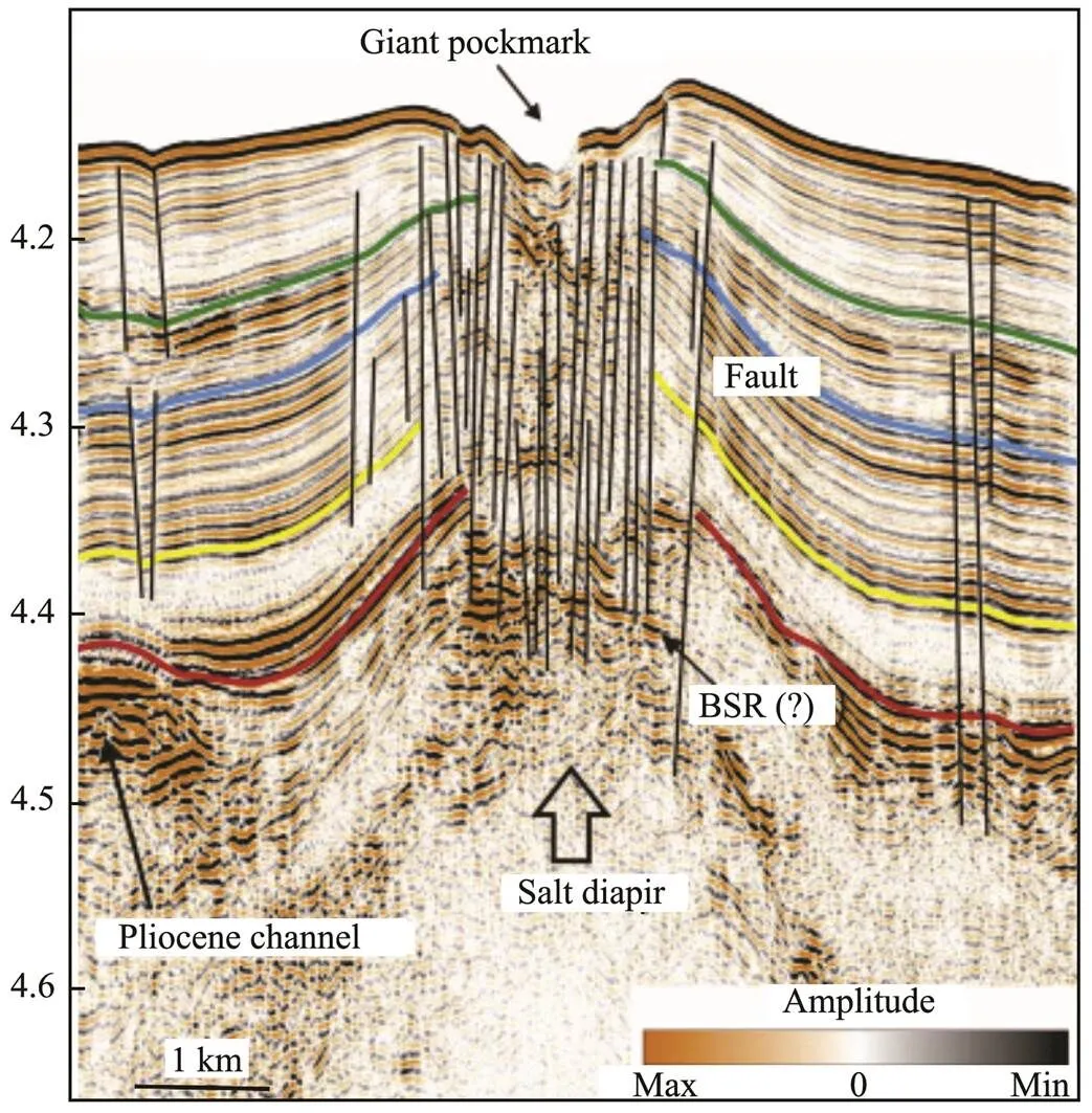
Fig.2 Seismic profile across a giant pockmark that is located above faults connecting the seafloor to the diapiric structure in the lower Congo Basin (Wenau et al., 2017).
3 The Shape of Pockmarks and Their Contribution Factors
Pockmarks have differences in both magnitude and shape,and thus there are two main methods for the classifications of pockmarks. According to diameter, Chen. (2015) divided pockmarks into four groups including unit-pockmarks (<5m), normal pockmarks (5–100m), giant-pock- marks (hundreds of meters) and mega-pockmarks (thousands of meters). Basing on this classification, most of the pockmarks reported on the continental margin fall in the group of normal pockmarks or giant-pockmarks with their depths <100m (Pilcher and Argent, 2007; Table 1). Where- as few mega-pockmarks that link to particular geological settings occur in the Bay of Biscay (Iglesias., 2010), the Brazilian Atlantic margin (Miller., 2015) and the South China Sea (Sun., 2011b; Chen., 2015), and only few unit-pockmarks are reported since their recognition is depend on high-resolution bathymetric survey.
According to the shapes in planar view, pockmarks have been classified into circular, ellipse, crescent, elongated, eye-shape, comet-shape and irregular pockmarks by Hov- land. (2002) and Chen. (2015). Following this classification, here we add the ring-shape pockmarks and surmise the research progress of different types of pockmarks, focusing on how pockmarks form, and on how con- tribution factors maintain and reconstruct the pockmarks.
3.1 Circular Pockmarks
Circular pockmarks are the most common type in the seepage areas (Table 1), which are widely occur in homogeneous stress field and stable sedimentary environment. The locations of circular pockmarks are usually restricted in the areas where gas chimneys/pipes that originate at the top of gas reservoirs breach the seafloor (Fig.3a). For the formation of gas chimney, Cathles. (2010) established a mathematical model simulating the processes that gas rises through a capillary seal,., as a chimney grows upward, the rising gas drives porewater to overflow the seafloor, liquefying the sediments and facilitating the seafloor erosion by bottom water current (Fig.4). This model and typical pockmark examples on the Norwegian continental margin and the Blake Ridge show that during the early stages small unit-pockmarks together with sediment doming begin to form when the chimney extends about half way to the seafloor (Fig.4c), and finally once the rising gas chimney gets close to the seafloor, normal pockmarks with the same diameter as the chimney are established (Fig.4d, Cathles., 2010; Hovland., 2010). As a result, growing gas chimney, sediment doming and liquefaction of shallow sediments are precursors of pockmarks. Koch. (2015) also proposed that the buoyancy of accumulated gas below less-permeable sediment layers may cause sediment doming, and they established a quantitative relationship between gas column heights below the sealing layer and the geometric characteristics of domes, which is consistent with the geophysical data from Opou- awe Bank, offshore New Zealand. However, it is worth mentioning that not all of gas seepages, even in the form of bubble escaping and gas controlled sediment doming, can eventually lead to the formation of pockmarks,., pockmarks are absence in the gas flares areas in the North Sea (Mau., 2014) or around the dome structure offshore New Zealand (Koch., 2015).
3.2 Elliptical Pockmarks
On the seafloor influenced by strong bottom currents, the shapes of pockmarks are asymmetrical ellipse, which is dictated by the current velocities and their persistance (Fig.3b). Base on modeling and field observation, Hammer. (2009) suggest that the upwelling caused by the deflection of water currents in pockmarks could reduce the sedimentation rate and winnow the fine particles inside the pockmarks, keeping the pockmarks infilling even whenthe gas seepages have stopped. Schattner. (2016) com- pared the pockmarks scattered across two different flow fields, and further proposed that currents with velocity more than 20cms?1could maintain the steepness of pock mark flank. They revealed that the pockmarks were in conic shape originally, while the bottom currents lengthen the pockmarks in the direction of flow and change their skewness.
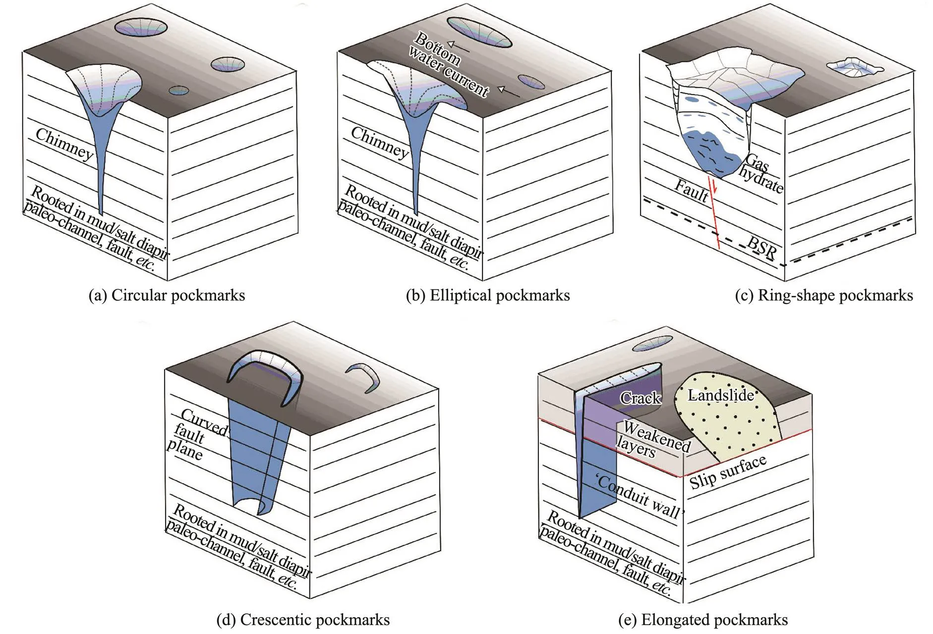
Fig.3 Geometrical characteristics and subseafloor structures for the five types of pockmarks. (a) and (c) are modified after Riboulot et al. (2016).
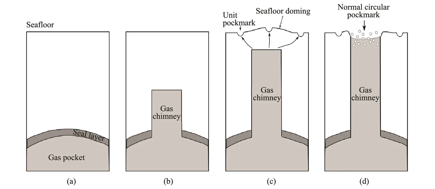
Fig.4 the formation mechanisms of normal circular pockmarks (Cathles et al., 2010; Hovland et al., 2010; Koch et al., 2015). (a), Gas is trapped under a seal layer; (b), as the gas accumulates to a certain thickness, gas chimney forms; (c), gas chimney continues to grow up, and the accumulation of gas at the subseafloor causes buoyance-controlled seafloor doming. In addition, unit-pockmarks start to appear due to the dewatering or degassing; (d), Gas chimney finally reaches the seafloor, unit-pockmarks are merged into a normal circular pockmark.
3.3 Ring-Shape Pockmarks
The ring-shape pockmarks show irregular seafloor mor- phology which are rimmed by a ring depression or circular moat (Figs.3c and 5a). The ring-shape pockmarks are not associated with vertical chimneys, but closely related to the crystallization and decomposition of gas hydrates in the underlying sedimentary layers (Figs.3c and 5b). Very- high-resolution seismic imaging, sedimentological analysis and numerical modelling revealed that the crystallization of gas hydrates within cohesive clay layers along ver- tical fractures is the prerequisite for the formation of this kind of pockmarks.
In the first stage, the gas migrates upward into the gas hydrate stability zone, forming gas hydrate dome and creating a ‘V’-shape fracture in the overlying layers, which determines the shapes and sizes of the pockmarks (Fig.6a, Riboulot., 2016). In the second stage, when the supply of gas is adequate, gas hydrate is continually produced along the ‘V’-shape fractures, impeding the gas migration, Then free gases migrate through the border of gas hydrate occurrence zones, forming a ring pockmark structure around the central gas hydrate-rich zone (Fig.6b, Sultan., 2014; Wei., 2015; Riboulot., 2016). However, if the amount of upward migrating gas reduces, gas hydrates will dissolute and the dome-like structure will collapse in the center area of pockmarks. Consequently, a relatively regular pockmark is formed, like the circular pockmarks (Sultan., 2014).
3.4 Crescentic Pockmarks
Crescentic-shape depressions have been found in the western African margin, the South China Sea and the Me- diterranean Sea (Table 1). The formation mechanism of such depressions is open to dispute. Verdicchio and Trin- cardi (2006), and Duarte. (2010) suggested that they are caused by the erosion of bottom currents or turbidity currents, while Chen. (2015) and Sun. (2011) believed they are crescentic pockmarks that link to gas see- pages in the northern Zhongjiannan Basin, South China Sea. Sun. (2011) proposed that these pockmarks were originally circular or sub-circular, and the crescentic appearance is shaped subsequently by the seasonal variations of bottom water currents. In contrast, basing on multi- beam bathymetric map and subseafloor seismic profiles, the latest research of Chen. (2015, 2018) revealed that the crescentic pockmarks with curved fractures below are caused by both fluid escape and sediment slumping (Fig.3d).
3.5 Elongated Pockmarks
Elongated pockmarks (also called ‘gas blowouts’, ‘blind valley’, ‘elongated depressions’; Figs.3e and 7a) have the ratios of major axis to minor axis length (3:1 to 15:1, Hill., 2004; León., 2010; Xu., 2018) higher than those of the elliptical pockmarks affected by water currents (1:1–7.3:1,., pockmarks offshore Brazil reported by Schattner., 2016). Different from in the areas with pockmark gullies, small individual circular pockmarks are usually not present in the areas with elongated pockmarks. The elongated pockmarks are formed not only by gas venting, but also by regional tectonic activities to varying extent. Elongated depressions are typical pockmarks that are produced by the combine effects of gas seepage and landsliding. As reported by Xu. (2018), in the early stage of the pockmark formation, pore pressure increases the break-through of gas bubbles at individual locations, forming gas chimneys (Fig.8a). During the second stage, the weakened conduit(s) turn into a growing gas migration plane in parallel to the slope under the potential of gravitational forces, which will develop over time in the observed acoustic turbid ‘conduit wall’ with gas pockets (Fig.8b,., gas focusing conduit wall in Fig.7b). In the last stage, tension fractures occur together with landslides during one mass movement event. The ‘conduit walls’ develop further and give priority to tensional fractures/ cracks causing the acoustic turbidity zones in shallow sedimentary layers to be lengthened and widened (., the tensional crack in Fig.7b), forming asymmetric elongated depressions on the seafloor (Fig.8c). Finally, the elongated depression and the underneath ‘conduit walls’ or tensional cracks might transform into headwalls of sliding sites, facilitating the upslope retrogression of mass movement. Other elongated pockmarks include ‘gas blowouts’ and ‘blind valleys’. The former is formed by rapid gas eruptions in downslope creeping continental slopes (Hill., 2004), while the latter is defined as giant, elongated fault features comprising collapses and mega-pockmarks which usually occurred above anticlines (León., 2010).
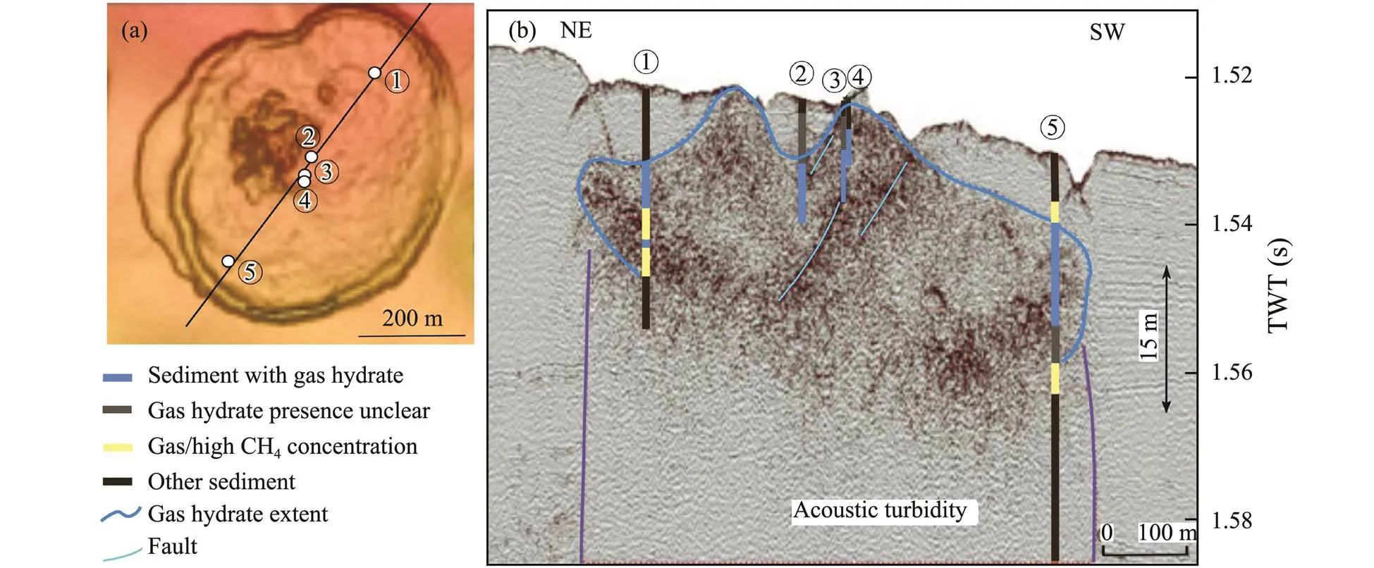
Fig.5 (a) Bathymetric map of the ring-shape pockmark (after de Prunelé et al., 2017), the location of seismic profile and sediment cores in (b) are shown; (b) seismic profiles crossing the ring-shape pockmark, gas and gas hydrates occurred in sediment cores are projected in the profile (after Wei et al., 2015).
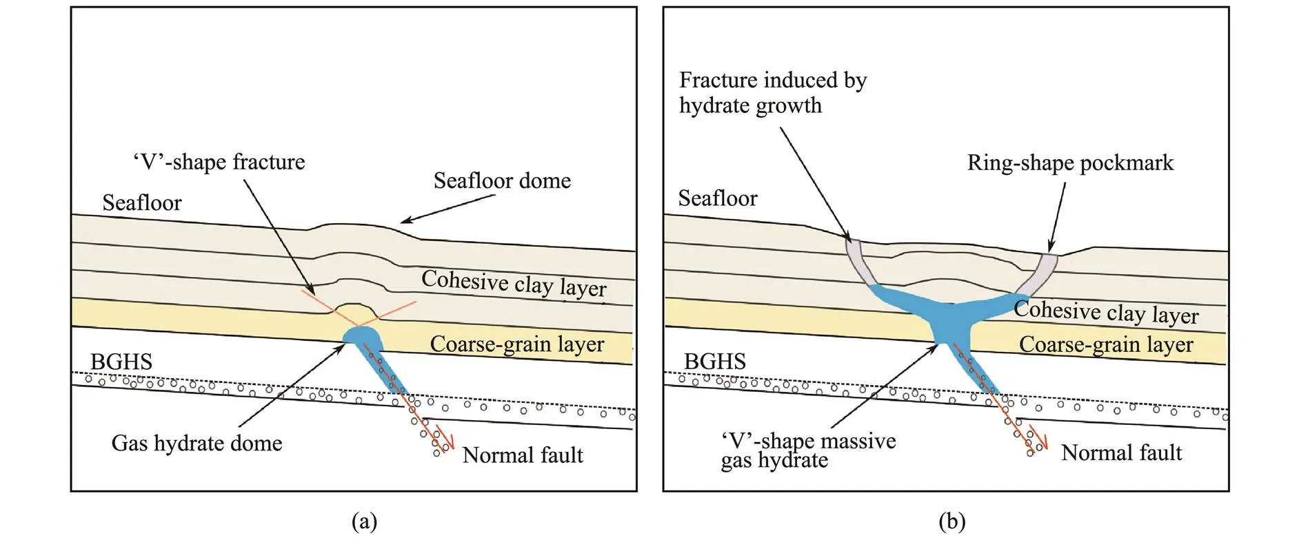
Fig.6 The schematic diagram of formation mechanisms for ring-shape pockmarks (Riboulot et al., 2016).
4 Composition Pattern
Pockmarks sometimes appear combination pattern,., general pockmark group and belt-like pockmark gullies, which are determined by the distribution of gas chimneys.
4.1 Pockmark Group
A typical pockmark group contains a significant num-ber of pockmarks in various sizes which are distributed in a certain pattern. Hundreds of unit-pockmarks occur at the surrounding area of several normal pockmarks above a main gas chimney, and the density of unit-pockmarks in- creases towards the rims of the normal-pockmarks (Fig.4d). The normal-pockmarks represent periodic or intermittent gas eruptions coming from the underneath main gas chim- ney, while the unit-pockmarks may link to a large amount of branches extending from the gas chimney,., minor fractures (Hovland., 2010, 2012). The unit-pockmarks may merge into normal-pockmarks, and normal- pockmarks may further develop over time into greater pockmarks,., giant-pockmarks and mega-pockmarks.
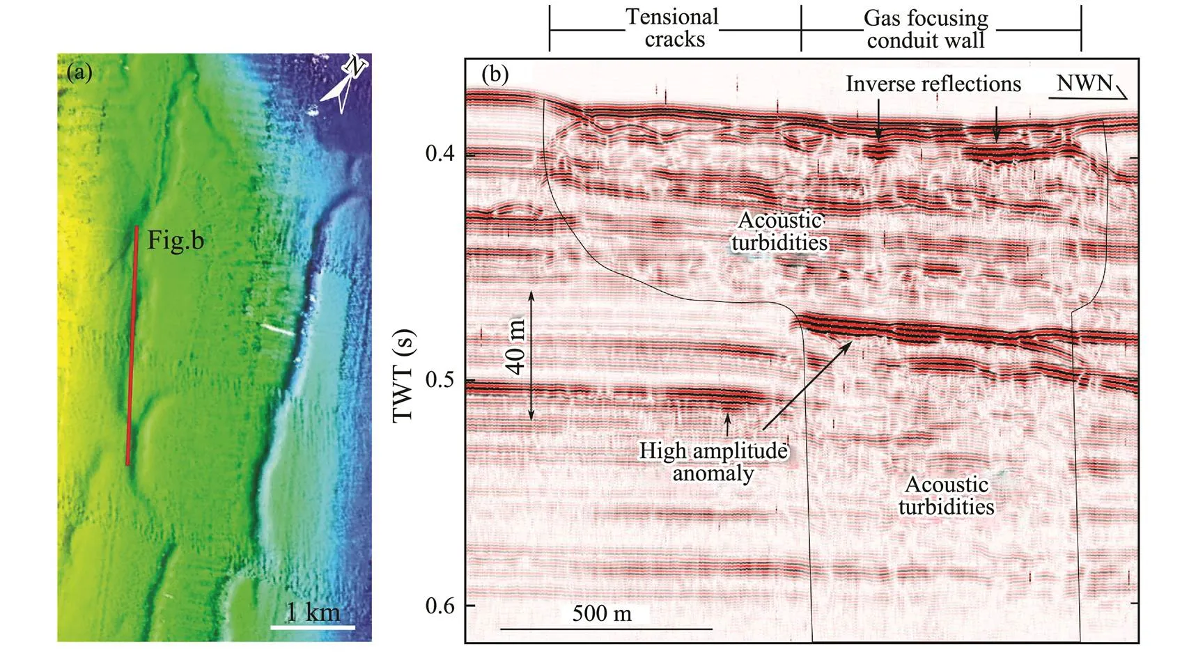
Fig.7 (a) Bathymetric map of the elongated pockmark, marked with the location of seismic profile in (b); (b) seismic profiles along the long axis of elongated pockmark (after Xu et al., 2018).

Fig.8 Schematic outlining the formation process of elongated depressions.
4.2 Pockmark Gully
Following a linear structure, such as faults and buried channels, gas chimneys and pockmarks may distribute in a bead-like pattern, and as the size of individual pockmark increases over time, the adjacent pockmarks may merge into pockmark gullies (Picher and Argent, 2007; Li., 2016). Pockmarks gullies are usually thousands of meters in width and tens thousands of meters in length, trending downslope. Pockmark gullies are not sediment transport pathways toward the deep basin, but may be the factor contributing to submarine geo-hazards (Picher and Argent, 2007; Chen., 2015).
5 The Formation Time of Pockmarks
The formation time of pockmarks are usually determined by U-Th isotope or radiocarbon age measurements on authigenic carbonate/Bathymodiolus mussel shell. The me- thane seepages in most of seafloor pockmarks, such as on the North Atlantic Margin, the Mediterranean Sea and the west African Margin, occurred during the last 25kyrB.P., corresponding to the Last Glacial Maximum, the last trans-gression and the Holocene (Plaza-Faverola., 2011; Hill., 2012; Riboulot., 2013; Ambrose., 2015; Bayon., 2015; Prouty., 2016; Sztybor and Rasmussen, 2016; de Prunelé., 2017; Mazzini., 2017). However, one pockmark in the South China Sea has stopped releasing methane since 40kyrB.P. (Luo., 2013), and several abandoned pockmarks are found totally buried in Pleistocene sediments identified by seismic profiles (?if?i., 2003; Andresen., 2008; Riboulot., 2013; de Prunelé., 2017; Xu., 2018).
In general, the intensities of methane seepages and the formation time of pockmarks are episodic and show difference in low and high latitudes. In the low latitudes, the formation time of pockmarks has no significant correlation with the global sea level change, and pockmarks have longer time span than those in the high latitudes,., the pockmarks in the Congo Fan, the Niger delta and the Mediterranean Sea are formed during 45.5–3kyrB.P., 13 –2.5kyrB.P. and 11.7–0.5kyrB.P. respectively. In contrast, in the high latitudes of the North Atlantic, typically in the Fram Strait and Svalbard-Barents-Norwegian continental margin, most of the pockmarks are displaced in the last deglaciation period between 17–7kyrB.P., which is attri- buted to climate change (Hill., 2012; Pau., 2014; Crémière., 2016; Sztybor and Rasmussen, 2016; Maz- zini., 2017).
However, how climate changes trigger the gas seepages and the formation of pockmarks in the high latitudes are still in dispute. In shallow areas with the water depth less than 500m, several studies on oxygen isotopic composition of authigenic carbonate minerals link the gas seepages in the pockmarks to the dissociation of gas hydrate, and mathematical model results revealed that the decomposing of gas hydrate are mainly caused either by the removal of ice overburden (Pau, 2014; Crémière., 2016), or by rising bottom water temperature (Pau., 2014; Mazzini., 2017). The methane seepages in the high latitudes may also be intensified by the rapid melting of ice sheet, either due to the increase of seismic activities that response to isostatic rebound especially around the mid-oceanic ridge system (Sztybor and Rasmussen, 2016), or caused by pressure decrease and ensuing isostatic uplift along glacial ploughmarks (Tasianan., 2018). Be- sides, Hustoft. (2009) and Hill. (2012) proposed that the pockmarks offshore in mid-Norway are formed by the compaction-driven overpressure corresponding to the high sedimentation rates during the last deglaciation period, which is recently verified by combined study of seismo-stratigraphic framework, radiocarbon age calibration, age-depth-model and 4D sedimentation reconstruction (Karstens., 2018).
6 Future Prospects
In summaries, the research on the distribution of pock- marks controlled by geological structures, and the research on the appearances of pockmarks shaping by bottom currents, landslides and gas hydrates are fairly mature, while there are still some questions on the studies about the formation time of pockmarks and their relationship with global climate change. As mentioned above, most of the pockmarks in the high latitudes have occurred during the last deglacial period, being obviously restricted by the climate change. However, the trigger mechanism of climate change on the formation of pockmarks is still unclear and therefore further researches should be focused on distinguishing the pockmarks formed by decomposition of gas hydrate due to temperature or pressure changes from those formed by gas seepages due to seismic activities or high sedimentation rates.
In relating to the influences of methane seepages on the atmospheric carbon content, previous studies show that most of the methane seeped lastingly and slowly through mature pockmarks are consumed in shallow sediment layers and ocean water column (Crémière., 2016). Thus we think that more attention should be paid to the early stage of pockmark formation,., development of gas chimneys and the doming of sediments driven by gas buoyancy. In addition, submarine mud diapirs and mass movements, which may also release methane in large scale, closely interact with the formation of pockmarks. For example, gas migration may not only form elongated and crescentic pockmarks in the seafloor, but also facilitate the early development of mass movements (Chen., 2015; Xu., 2018). Buried landslide deposits without layered structure may provide barriers for fluid migration (Riboulot., 2014). Pockmarks often occur above or around mud diapir,. In fact, since submarine pockmarks, mud diapirs and landslides are all significantly impacted by sediment overpressure, no matter which one occurs first, it can release the sediment overpressure rapidly and further affect the formation of the subsequent one. As a result, geochemical and geophysical methods can be utilized to do further researches on spatio-temporal relation between pockmarks and mass movements, and the relation between pockmarks and mud diapirs as well.
Acknowledgements
This work was supported by the National Natural Science Foundation of China (Nos. 41606044, 41906068, 91 858208), the National Key Research and Development Program (No. 2018YFC031000303), the Taishan Scholar Special Experts Project (No. ts201712079) and the Marine Geological Survey Program of China Geological Survey (No. DD20190819). We also appreciate the two anonymous reviewers for their valuable suggestions.
Ambrose, W. G., Panieri, G., Schneider, A., Plaza-Faverola, A., Carroll, M. L., ?str?m, E. K. L., Locke, W. L., and Carroll, J., 2015. Bivalve shell horizons in seafloor pockmarks of the last glacial-interglacial transition: A thousand years of methane emissions in the Arctic Ocean., 16: 4108-4129, DOI: 10.1002/2015GC005980.
Andresen, K. J., Huuse, M., and Clausen, O. R., 2008. Morpho- logy and distribution of Oligocene and Miocene pockmarks in the Danish North Sea–Implications for bottom current activity and fluid migration., 20: 445-466.
Andrews, B. D., Brothers, L. L., and Barnhardt, W. A., 2010. Automated feature extraction and spatial organization of seafloor pockmarks, Belfast Bay, Maine, USA., 124: 55-64, DOI: 10.1016/j.geomorph.2010.08.009.
Bayon, G., Gideon, M., Etoubleau, H., Caprais, J., and Sultan, N., 2015. U-Th isotope constraints on gas hydrate and pockmark dynamics at the Niger Delta margin., 370: 87- 98.
Baltzer, A., Ehrhold, A., Rigolet, C., Souron, A., Cordier, C., Clouet, H., and Dubois, S. F., 2014. Geophysical exploration of an active pockmark field in the Bay of Concarneau, sou- thern Brittany, and implications for resident suspension feeders., 34: 215-230.
Brothers, L. L., Kelley, J. T., Belknap, D. F., Barnhardt, W. A., Andrews, B. D., and Maynard, M. L., 2011. More than a cen- tury of bathymetric observations and present-day shallow sedi- ment characterization in Belfast Bay, Maine, USA: Implica- tions for pockmark field longevity., 31: 237-248.
Cathles, L. M., Su, Z., and Chen, D., 2010. The physics of gas chimney and pockmark formation, with implications for assess- ment of seafloor hazards and gas sequestration., 27: 82-91.
Chand, S., Cremiere, A., Lepland, A., Thorsnes, T., Brunstad, H., and Stoddart, D., 2017. Long-term fluid expulsion revealed by carbonate crusts and pockmarks connected to subsurface gas anomalies and palaeo-channels in the central North Sea., 37: 215-227.
Chen, J., Song, H., Guan, Y., Pinheiro, L. M., and Geng, M., 2018. Geological and oceanographic controls on seabed fluid escape structures in the northern Zhongjiannan Basin, South China Sea., 168: 38-47.
Chen, J., Song, H., Guan, Y., Yang, S., Pinheiro, L. M., Bai, Y., Liu, B., and Geng, M., 2015. Morphologies, classification and genesis of pockmarks, mud volcanoes and associated fluid escape features in the northern Zhongjiannan Basin, South China Sea., 122: 106-117.
Chen, S. C., Hsu, S. K., Tsai, C. H., Ku, C. Y., Yeh, Y. C., and Wang, Y., 2010. Gas seepage, pockmarks and mud volcanoes in the near shore of SW Taiwan., 31: 133-147, DOI: 10.1007/s11001-010-9097-6.
Christodoulou, D., Papatheodorou, G., Ferentinos, G., and Masson, M., 2003. Active seepage in two contrasting pockmark fields in the Patras and Corinth Gulfs, Greece., 23: 194-199, DOI: 10.1007/s00367-003-0151-0.
?if?i, G., Dondurur, D., and Ergün, M., 2003. Deep and shallow structures of large pockmarks in the Turkish shelf, Eastern Black Sea., 23: 311-322.
Crémière, A., Lepland, A., Chand, S., Sahy, D., Condon, D. J., Noble, S. R., Martma, T., Thorsnes, T., Sauer, S., and Brunstad, H., 2016. Timescales of methane seepage on the Norwegian margin following collapse of the Scandinavian Ice Sheet., 7: 11509, DOI: 10.1038/ncomms11509.
Dalla Valle, G., and Gamberi, F., 2011. Pockmarks and seafloor instability in the Olbia continental slope (northeastern Sardi- nian margin, Tyrrhenian Sea)., 32: 193-205, DOI: 10.1007/s11001-011-9133-1.
Dandapath, S., Chakraborty, B., Karisiddaiah, S. M., Menezes, A., Ranade, G., Fernandes, W., Naik, D. K., and Prudhvi Raju, K. N., 2010. Morphology of pockmarks along the western continental margin of India: Employing multibeam bathy- metry and backscatter data., 27: 2107-2117, DOI: 10.1016/j.marpetgeo.2010.09.005.
Dandapath, S., Chakraborty, B., Maslov, N., Karisiddaiah, S. M., Ghosh, D., Fernandes, W., and Menezes, A., 2012. Characteri- zation of seafloor pockmark seepage of hydrocarbons employ- ing fractal: A case study from the western continental margin of India., 29: 115-128.
de Mahiques, M. M., Schattner, U., Lazar, M., Sumida, P. Y. G., and de Souza, L. A. P., 2017. An extensive pockmark field on the upper Atlantic margin of Southeast Brazil: Spatial analysis and its relationship with salt diapirism., 3: e00257, DOI: 10.1016/j.heliyon.2017.e00257.
de Prunelé, A., Ruffine, L., Riboulot, V., Peters, C. A., Croguen- nec, C., Guyader, V., Pape, T., Bollinger, C., Bayon, G., Caprais, J. C., Germain, Y., Donval, J. P., Marsset, T., Bohrmann, G., Géli, L., Rabiu, A., Lescanne, M., Cauquil, E., and Sultan, N., 2017. Focused hydrocarbon-migration in shallow sediments of a pockmark cluster in the Niger Delta (off Nigeria)., 18: 93-112.
Di, P., Huang, H., Huang, B., He, J., and Chen, D., 2012. Seabed pockmark formation associated with mud diapir development and fluid activities in the Yinggehai Basin of the South China Sea., 31 (5): 26-36 (in Chinese with English abstract).
Dimitrov, L., and Woodside, J., 2003. Deep sea pockmark en- vironments in the eastern Mediterranean., 195 (1-4): 263-276.
Duarte, J. C., Terrinha, P., Rosas, F. M., Valadares, V., Pinheiro, L. M., Matias, L., Magalh?es, V., and Roque, C., 2010. Cre- scent-shaped morphotectonic features in the Gulf of Cadiz (offshore SW Iberia)., 271: 236-249.
Eichhubl, P., Greene, H. G., and Maher, N., 2002. Physiography of an active transpressive margin basin: High-resolution bathy- metry of the Santa Barbara Basin, Southern California con- tinental borderland., 184: 95-120.
Fandel, C. L., Lippmann, T. C., Foster, D. L., and Brothers, L. L., 2016a. Observations of pockmark flow structure in BelfastBay, Maine, Part 2: Evidence for cavity flow., 37 (1): 1-8.
Fandel, C. L., Lippmann, T. C., Irish, J. D., and Brothers, L. L., 2016b. Observations of pockmark flow structure in Belfast Bay, Maine, Part 1: Current-induced mixing.,37 (1): 1-14, DOI: 10.1007/s00367-016-0472-4.
Fandel, C. L., Lippmann, T. C., Foster, D. L., and Brothers, L. L., 2017. Observations of pockmark flow structure in Belfast Bay, Maine, Part 3: Implications for sediment transport., 37 (1): 23-34.
Feldens, P., Schmidt, M., Mücke, I., Augustin, N., Al-Farawati, R., Orif, M., and Faber, E., 2016. Expelled subsalt fluids form a pockmark field in the eastern Red Sea., 36: 339-352, DOI: 10.1007/s00367-016-0451-9.
Gamberi, F., and Rovere, M., 2010. Mud diapirs, mud volcanoes and fluid flow in the rear of the Calabrian Arc Orogenic We- dge (southeastern Tyrrhenian Sea)., 22: 452- 464, DOI: 10.1111/j.1365-2117.2010.00473.x.
Gay, A., Lopez, M., Cochonat, P., Levaché, D., Sermondadaz, G., and Seranne, M., 2006a. Evidences of early to late fluid mi- gration from an upper Miocene turbiditic channel revealed by 3D seismic coupled to geochemical sampling within seafloor pockmarks, Lower Congo Basin., 23: 387-399.
Gay, A., Lopez, M., Cochonat, P., Séranne, M., Levaché, D., and Sermondadaz, G., 2006b. Isolated seafloor pockmarks linked to BSRs, fluid chimneys, polygonal faults and stacked Oli- gocene-Miocene turbiditic palaeochannels in the Lower Congo Basin., 226: 25-40.
Gay, A., Lopez, M., Cochonat, P., Sultan, N., Cauquil, E., and Brigaud, F., 2003. Sinuous pockmark belt as indicator of a shallow buried turbiditic channel on the lower slope of the Congo Basin, West African margin., 216: 173-190, DOI: 10.1144/gsl.sp.2003.216.01.12.
Gay, A., Lopez, M., Ondreas, H., Charlou, J. L., and Sermon- dadaz, G., Cochonat, P., 2006c. Seafloor facies related to up- ward methane flux within a giant pockmark of the Lower Congo Basin., 226: 81-95.
Gay, A., Takano, Y., Gilhooly, W. P., Berndt, C., Heeschen, K., Suzuki, N., Saegusa, S., Nakagawa, F., Tsunogai, U., Jiang, S. Y., and Lopez, M., 2011. Geophysical and geochemical evi- dence of large scale fluid flow within shallow sediments in the eastern Gulf of Mexico, offshore Louisiana., 11: 34-47, DOI: 10.1111/j.1468-8123.2010.00304.x.
Goswami, B. K., Weitemeyer, K. A., Bünz, S., Timothy, A., West- brook, G. K., Ker, S., and Sinha, M. C., 2017. Variations in pockmark composition at the Vestnesa Ridge: Insights from marine controlled source electromagnetic and seismic data., 18 (3): 1111-1125.
Hammer, ?., Webb, K. E., and Depreiter, D., 2009. Nu- merical simulation of upwelling currents in pockmarks, and data from the Inner Oslofjord, Norway., 29: 269- 275, DOI: 10.1007/s00367-009-0140-z.
Hasiotis, T., Papatheodorou, G., and Ferentinos, G., 2002. A string of large and deep gas-induced depressions (pockmarks) offshore Killini Peninsula, western Greece.,22: 142-149, DOI: 10.1007/s00367-002-0106-x.
He, J., Zhang, W., and Lu, Z., 2017. Seepage system of oil-gas and its exploration in Yinggehai Basin located at northwest of South China Sea., 2 (1): 29-41, DOI: 10.1016/j.jnggs.2017.01.001.
Hill, J. C., Driscoll, N. W., Weissel, J. K., and Goff, J. A., 2004. Large-scale elongated gas blowouts along the U.S. Atlantic margin., 109: 1-14, DOI: 10.1029/2004JB002969.
Hill, T. M., Paull, C. K., and Critser, R. B., 2012. Glacial and deglacial seafloor methane emissions from pockmarks on the northern flank of the Storegga Slide complex., 32: 73-84, DOI: 10.1007/s00367-011-0258-7.
Hjelstuen, B. O., Haflidason, H., Sejrup, H. P., and Nyg?rd, A., 2010. Sedimentary and structural control on pockmark deve- lopment-evidence from the Nyegga pockmark field, NW Euro- pean margin., 30: 221-230.
Hovland, M., Heggland, R., De Vries, M. H., and Tjelta, T. I., 2010. Unit-pockmarks and their potential significance for pre- dicting fluid flow., 27: 1190- 1199, DOI: 10.1016/j.marpetgeo.2010.02.005.
Hovland, M., Jensen, S., and Indreiten, T., 2012. Unit pockmarks associated with Lophelia coral reefs off mid-Norway: More evidence of control by ‘fertilizing’ bottom currents., 32: 545-554.
Hustoft, S., Bünz, S., and Mienert, J., 2010. Three-dimensional seismic analysis of the morphology and spatial distribution of chimneys beneath the Nyegga pockmark field, offshore mid- Norway., 22: 465-480.
Hustoft, S., Dugan, B., and Mienert, J., 2009. Effects of rapid sedimentation on developing the Nyegga pockmark field: Constraints from hydrological modeling and 3-D seismic data, offshore mid-Norway.,10 (6): Q06012, DOI: 10.1029/2009GC002409.
Iglesias, J., Ercilla, G., García-Gil, S., and Judd, A. G., 2010. Pockforms: An evaluation of pockmark-like seabed features on the Landes Plateau, Bay of Biscay., 30: 207-219, DOI: 10.1007/s00367-009-0182-2.
Ingrassia, M., Martorelli, E., Bosman, A., Macelloni, L., Sposato, A., and Chiocci, F. L., 2015. The zannone giant pockmark: First evidence of a giant complex seeping structure in shallow- water, central Mediterranean Sea, Italy.y, 363: 38-51, DOI: 10.1016/j.margeo.2015.02.005.
Jeong, K. S., Cho, J. H., Kim, S. R., Hyun, S., and Tsunogai, U., 2004. Geophysical and geochemical observations on actively seeping hydrocarbon gases on the south-eastern Yellow Sea continental shelf., 24: 53-62.
Karstens, J., Haflidason, H., Becker, L. W. M., Berndt, C., Rupke, L., Planke, S., Liebetrau, V., Schmidt, M., and Mienert, J., 2018. Glacigenic sedimentation pulses triggered post-glacial gas hydrate dissociation., 9: 635.
King, L. H., and MacLean, B., 1970. Pockmarks on the Scotian Shelf., 81: 3141-3148, DOI: 10.1130/0016-7606(1970)81[3141:POTSS]2.0.CO;2.
Kluesner, J. W., Silver, E. A., Bangs, N. L., McIntosh, K. D., Gibson, J., Orange, D., Ranero, C. R., and Von Huene, R., 2013. High density of structurally controlled, shallow to deep water fluid seep indicators imaged offshore Costa Rica., 14: 519-539.
Koch, S., Berndt, C., Bialas, J., Haeckel, M., Crutchley, G., Pa- penberg, C., Klaeschen, D., and Greinert, J., 2015. Gas-con- trolled seafloor doming., 43 (7): 571-574.
Kopf, A. J., 2002. Significance of mud volcanism., 40 (2): 1005, DOI: 10.1029/2000RG000093.
Lastras, G., Canals, M., Urgeles, R., Hughes-Clarke, J. E., and Acosta, J., 2004. Shallow slides and pockmark swarms in the Eivissa Channel, western Mediterranean Sea., 51: 837-850, DOI: 10.1111/j.1365-3091.2004.00654.x.
León, R., Somoza, L., Medialdea, T., González, F. J., Gimenez- Moreno, C. J., and Pérez-López, R., 2014. Pockmarks on either side of the strait of Gibraltar: Formation from overpressured shallow contourite gas reservoirs and internal wave action during the last glacial sea-level lowstand?, 34: 131-151, DOI: 10.1007/s00367-014-0358-2.
León, R., Somoza, L., Medialdea, T., Hernández-Molina, F. J., Vázquez, J. T., Díaz-del-Rio, V., and González, F. J., 2010. Pockmarks, collapses and blind valleys in the Gulf of Cádiz., 30 (3-4): 231-247.
Li, J., Wu, S., Hu, G., and Zhang, J., 2016. The characteristics and distribution pattern of seafloor sinuous pockmark train in the Niger Delta Basin, West Africa., 90 (3): 1057-1058.
Li, L., Pei, D., Du, P., Yi, R., Zheng, B., and Wang, M., 2013. Architecture, character, evolution and genesis of seabed pock- marks: A case study to the continental slope in Rio Muni Basin, West Africa., 18: 53-58.
Luo, M., Chen, L., Wang, S., Yan, W., Wang, H., and Chen, D., 2013. Pockmark activity inferred from pore water geoche- mistry in shallow sediments of the pockmark field in south- western Xisha uplift, northwestern South China Sea., 48: 247-259.
Maia, R. A., Cartwright, J., and Andersen, E., 2016. Shallow plumbing systems inferred from spatial analysis of pockmark arrays., 77: 865-881.
Marinaro, G., Etiope, G., Bue, N. L., Favali, P., Papatheodorou, G., Christodoulou, D., Furlan, F., Gasparoni, F., Ferentinos, G., Masson, M., and Rolin, J. F., 2006. Monitoring of a methane- seeping pockmark by cabled benthic observatory (Patras Gulf, Greece)., 26: 297-302.
Masoumi, S., Reuning, L., Back, S., Sandrin, A., and Kukla, P. A., 2014. Buried pockmarks on the top chalk surface of the Danish North Sea and their potential significance for interpre- ting palaeocirculation patterns., 103: 563-578, DOI: 10.1007/s00531-013-0977-2.
Mau, S., Gentz, T., K?rber, J. H., Torres, M., R?mer, M., Sahling, H., Wintersteller, P., Martinez, R., Schlüter, M., and Helmke, E., 2014. Seasonal methane accumulation and release from a gas emission site in the central North Sea., 11: 5261-5276.
Mazzini, A., Svensen, H. H., Forsberg, C. F., Linge, H., Lauritzen, S. E., Haflidason, H., Hammer, ?., Planke, S., and Tjelta, T. I., 2017. A climatic trigger for the giant troll pockmark field in the northern North Sea., 464: 24-34, DOI: 10.1016/j.epsl.2017.02.014.
Mazzini, A., Svensen, H. H., Planke, S., Forsberg, C. F., and Tjelta, T. I., 2016. Pockmarks and methanogenic carbonates above the giant Troll gas field in the Norwegian North Sea., 373: 26-38.
McAdoo, B. G., Orange, D. L., Silver, E. A., McIntosh, K., Abbott, L., Galewsky, J., Kahn, L., and Protti, M., 1996. Sea?oor struc- tural observations, Costa Rica accretionary prism., 23: 883-886.
Miller, D. J., Ketzer, J. M., Viana, A. R., Kowsmann, R. O., Freire,A. F. M., Oreiro, S. G., Augustin, A. H., Lourega, R. V., Rodri- gues, L. F., Heemann, R., Preissler, A. G., Machado, C. X., and Sbrissa, G. F., 2015. Natural gas hydrates in the Rio Grande Cone (Brazil): A new province in the western South Atlantic., 67: 187-196.
Moss, J. L., Cartwright, J., and Moore, R., 2012. Evidence for fluid migration following pockmark formation: Examples from the Nile deep sea fan., 303-306: 1-13.
Ondréas, H., Olu, K., Fouquet, Y., Charlou, J. L., Gay, A., Dennielou, B., Donval, J. P., Fifis, A., Nadalig, T., Cochonat, P., Cauquil, E., Bourillet, J. F., Moigne, M. L., and Sibuet, M., 2005. ROV study of a giant pockmark on the Gabon continental margin.s, 25: 281-292.
Pau, M., Gisler, G., and Hammer, ?., 2014. Experimental in- vestigation of the hydrodynamics in pockmarks using particle tracking velocimetry.s, 34: 11-19.
Paull, C. K., Ussler, W., Holbrook, W. S., Hill, T. M., Keaten, R., Mienert, J., Haflidason, H., Johnson, J. E., Winters, W. J., and Lorenson, T. D., 2008. Origin of pockmarks and chimney struc- tures on the flanks of the Storegga Slide, offshore Norway.s, 28: 43-51.
Pilcher, R., and Argent, J., 2007. Mega-pockmarks and linear pockmark trains on the West African continental margin., 244: 15-32.
Pinet, N., Duchesne, M., and Lavoie, D., 2010. Linking a linear pockmark train with a buried Palaeozoic structure: A case study from the St. Lawrence Estuary.s, 30: 517-522, DOI: 10.1007/s00367-009-0179-x.
Plaza-Faverola, A., Bünz, S., and Mienert, J., 2011. Repeated fluid expulsion through sub-seabed chimneys offshore Nor- way in response to glacial cycles., 305: 297-308, DOI: 10.1016/j.epsl.2011.03.001.
Prouty, N. G., Sahy, D., Ruppel, C. D., Roark, E. B., Condon, D., Brooke, S., Ross, S. W., and Demopoulos, A. W. J., 2016. Insights into methane dynamics from analysis of authigenic carbonates and chemosynthetic mussels at newly-discovered Atlantic Margin seeps., 449: 332-344, DOI: 10.1016/j.epsl.2016.05.023.
Riboulot, V., Cattaneo, A., Sultan, N., Garziglia, S., Ker, S., Imbert, P., and Voisset, M., 2013. Sea-level change and free gas occurrence influencing a submarine landslide and pock- mark formation and distribution in deepwater Nigeria., 375: 78-91.
Riboulot, V., Sultan, N., Imbert, P., and Ker, S., 2016. Initiation of gas-hydrate pockmark in deep-water Nigeria: Geo-mecha- nical analysis and modelling., 434: 252-263, DOI: 10.1016/j.epsl.2015.11.047.
Roy, S., Hovland, M., and Braathen, A., 2016. Evidence of fluid seepage in Gr?nfjorden, Spitsbergen: Implications from an integrated acoustic study of seafloor morphology, marine sedimentsand tectonics., 380: 67-78.
Schattner, U., Lazar, M., Souza, L. A. P., ten Brink, U., and Mahiques, M. M., 2016. Pockmark asymmetry and seafloor currents in the Santos Basin offshore Brazil., 36: 457-464.
Sultan, N., Bohrmann, G., Ruffine, L., Pape, T., Riboulot, V., Colliat, J. L., de Prunele, A., Dennielou, B., Garziglia, S., Him- mler, T., Marsset, T., Peters, C. A., Rabiu, A., and Wei, J., 2014. Pockmark formation and evolution in deep water Nigeria: Rapid hydrate growthslow hydrate dissolution., 119: 2679-2694.
Sumida, P. Y. G., Yoshinaga, M. Y., Madureira, L. A. S. P., and Hovland, M., 2004. Seabed pockmarks associated with deep- water corals off SE Brazilian continental slope, Santos Basin., 207: 159-167.
Sun, Q., Wu, S., Hovland, M., Luo, P., Lu, Y., and Qu, T., 2011. The morphologies and genesis of mega-pockmarks near the Xisha uplift, South China Sea., 28: 1146-1156, DOI: 10.1016/j.marpetgeo.2011.03.003.
Szpak, M. T., Monteys, X., O’Reilly, S., Simpson, A. J., Garcia, X., Evans, R. L., Allen, C. C. R., McNally, D. J., Courtier- Murias, D., and Kelleher, B. P., 2012. Geophysical and geoche- mical survey of a large marine pockmark on the Malin Shelf, Ireland., 13: 1-18.
Sztybor, K., and Rasmussen, T. L., 2016. Diagenetic disturban- ces of marine sedimentary records from methane-influenced environments in the Fram Strait as indications of variation in seep intensity during the last 35000 years.,46: 212- 228.
Tasianas, A., Bünz, S., Bellwald, B., Hammer, O., Planke, S., Lebedeva-Icanova, N., and Krassakis, P., 2018. High-resolu- tion 3D seismic study of pockmarks and shallow fluid flow systems at the Sn?hvit hydrocarbon field in the SW Barents Sea., 403: 247-261.
Taviani, M., Angeletti, L., Ceregato, A., Foglini, F., Froglia, C., and Trincardi, F., 2013. The Gela Basin pockmark field in the Strait of Sicily (Mediterranean Sea): Chemosymbiotic faunal and carbonate signatures of postglacial to modern cold seepage., 10: 4653-4671.
Verdicchio, G., and Trincardi, F., 2006. Short-distance variability in slope bed-forms along the southwestern Adriatic Margin (central Mediterranean)., 234: 271-292.
Von Rad, U., Berner, U., Delisle, G.,Doose-Rolinski, H., Fechner, N., and Linke, P., 2000. Gas and fluid venting at the Makran accretionary wedge off Pakistan., 20 (1): 10-19.
Wang, H., Liu, H., Zhang, M., and Wang, X., 2016. Wave-induced seepage and its possible contribution to the formation of pockmarks in the Huanghe (Yellow) River Delta., 34: 200-211.
Wei, J., Pape, T., Sultan, N., Colliat, J. L., Himmler, T., Ruffine, L., de Prunelé, A., Dennielou, B., Garziglia, S., Marsset, T., Peters, C. A., Rabiu, A., and Bohrmann, G., 2015. Gas hydrate distributions in sediments of pockmarks from the Nigerian margin–Results and interpretation from shallow drilling.,59: 359-370.
Wenau, S., Spie?, V., Pape, T., and Fekete, N., 2017. Controlling mechanisms of giant deep water pockmarks in the Lower Congo Basin.,83: 140-157.
Xu, C., Greinert, J., Haeckel, M., Bialas, J., Dimitrov, L., and Zhao, G., 2018. The character and formation of elongated de- pressions on the upper Bulgarian Slope., 17: 555-562.
Zeppilli, D., Canals, M., and Danovaro, R., 2012. Pockmarks enhance deep-sea benthic biodiversity: A case study in the western Mediterranean Sea., 18: 832-846.
April1, 2018;
January 21, 2019;
May 29, 2019
? Ocean University of China, Science Press and Springer-Verlag GmbH Germany 2019
. Tel: 0086-532-66782962
E-mail: junhuixing@ouc.edu.cn
(Edited by Chen Wenwen)
 Journal of Ocean University of China2020年1期
- Journal of Ocean University of China的其它文章
- Screening and Characterization of Nitrite-Degrading Bacterial Isolates Using a Novel Culture Medium
- Purification and Characterization of a Novel Lipase from Antarctic Krill
- Quality Assessment of Frozen Solenocera crassicornis Treated with Sodium Metabisulphite by Soaking or Spraying
- Contribution of Mesoscale Eddies to the Subduction and Transport of North Pacific Eastern Subtropical Mode Water
- Semi-Empirical Algorithm for Wind Speed Retrieval from Gaofen-3 Quad-Polarization Strip Mode SAR Data
- An Effective Method of Prompting Juvenile Rainbow Trout (Oncorhynchus mykiss) to Cope with Heat Stress
