
Radiative Effectson TorrentialRainfallduring the Land fallof Typhoon Fitow(2013)
2016-08-12 03:41:40LingyunLOUandXiaofanLI
Advances in Atmospheric Sciences 2016年1期
Lingyun LOU and Xiaofan LI
SchoolofEarth Sciences,Zhejiang University,Hangzhou 310027
Radiative Effectson TorrentialRainfallduring the Land fallof Typhoon Fitow(2013)
Lingyun LOU and Xiaofan LI?
SchoolofEarth Sciences,Zhejiang University,Hangzhou 310027
Cloudm icrophysicaland rainfall responses to radiativeprocessesareexam ined through analysisof cloud-resolvingmodel sensitivity experiments of Typhoon Fitow(2013)during landfall.The budgetanalysis shows that the increase in themean rainfall caused by the exclusion of radiative effectsofwater clouds corresponds to the decrease in accretion of raindrops by cloud ice in the presence of radiative effects of ice clouds,but the rainfall is insensitive to radiative effects ofwater clouds in the absence of radiative effects of ice clouds.The increases in themean rainfall resulting from the removal of radiative effectsof ice clouds correspond to the enhanced netcondensation.The increases(decreases)inmaximum rainfall caused by the exclusion of radiative effects ofwater clouds in the presence(absence)of radiative effects of ice clouds,or the removal of radiative effects of ice clouds in the presence(absence)of radiative effects of water clouds,correspond mainly to the enhancements(reductions)in netcondensation.
Themean rain rate is a product of rain intensity and fractional rainfall coverage.The radiation-induced difference in themean rain rate is related to the difference in rain intensity.The radiation-induced difference in themaximum rain rate is associatedw ith the difference in the fractional coverageofmaximum rainfall.
radiative effects,rainfall,maximum rainfall,rain intensity,fractional rainfall coverage,net condensation,hydrometeor change
1. Introduction
During summer in the Northern Hem isphere,landfalling typhoons can cause severe floods along the coastal areas of eastern and southern China,resulting in regular economic loss.The rainfall during typhoon landfall isaffected by various physical processes and factors.Among them,cloud radiative processes play an important role in the development andmaintenanceof typhoon rainfall.The cloudsimpact thermal stratification through the reflection of solar radiation at the top of clouds and prevention of infrared radiation escaping into space.Such a change in temperature affects the net condensation through the change in saturation specific humidity and cloudm icrophysical processes.The rainfall can be influenced by cloud radiative processes through the developmentof thesecondary circulation induced by thedifference in radiativeheatingbetween cloudy and clear-sky areas(Gray and Jacobson,1977),destabilization of thermal stratification (Lilly,1988;Dudhia,1989),and the increase in relative hum idity(Tao etal.,1993)ordecrease in saturationm ixing ratio (Suietal.,1997,1998;Gao etal.,2009;Gao and Li,2010) in response to infrared radiative cooling.
Deep convection and torrential rainfall are often associatedw ith thedevelopmentof typhoons.The torrential rainfall during the landfallof typhoonsusually leads to naturaldisasters such as floods andmudslides,which can cause tremendous econom ic and human losses.Deep convection consists of water and ice clouds,depending on the air temperature. Ice cloudsare sem i-transparent to solar radiation butopaque to infrared radiation,and therefore have a strong greenhouse effect.On the contrary,water clouds reflectmostsolar radiation back to space due to their large optical thickness,and havea dominantcooling effect.Radiative processesofwater and ice cloudsmay impactupon the developmentof typhoon rainfall through the change in cloudm icrophysicalprocesses. Thus,studying the radiativeeffectsofwaterand ice cloudson typhoon rainfall can enhance understanding of the dominant physicalprocesses involved,and help determine the cloud radiative effectson typhoon rainfall intensity.
The objective of this study is to separately exam ine the radiative effectsofwater and ice cloudson the cloudmicrophysicsand rainfallassociated with a typhoon,through analysis of cloud m icrophysical budgetsw ith sensitivity experiments.Typhoon Fitow(2013)is selected for this purpose. Fitow(2013)strengthened to a typhoon in theearlymorningof 3October 2013 andmade landfallw ith amaximum w ind of 42 m s?1and m inimum pressure of 955 hPa at Fuding, Fujian,ataround 0115 LST(local standard time)7 October. Itweakened to a tropical storm at around 0500 LST 7 October.Fitow caused economic losses of over 10 billion US Dollars,mainly through significant floods in several cities in Zhejiang Province after its landfall in Fujian Province.Liet al.(2015)defined themodel domain mean rain rate as the productof rain intensity(RI)and fractional rainfall coverage (FRC).They analyzed the diurnal variation of tropical rainfallusing equilibrium cloud-resolvingmodelsimulation data and found that the diurnal variation of themean rain rate is associated w ith thatof FRC because the diurnal variation of RIis significantly weakened through the decrease in rainfall in the earlymorning hours.RIand FRCmay respond to radiative processes differently.Thus,radiative effects on RI and FRC w illbe examined.Themodel,large-scale forcing, and sensitivity experimentsarebriefly described in section 2. The control experiment is discussed in section 3.Cloudm icrophysical and rainfall responses to radiative processes are examined in section 4.A summary isprovided in section 5.
2. Model,experiments and analysis m ethodologies
A 2D cloud-resolving model(Soong and Ogura,1980; Soong and Tao,1980;Tao and Simpson,1993;Sui et al., 1994,1998;Lietal.,1999,2002)isused to simulate Typhoon Fitow(2013).Themodel(Gao and Li,2008;Li and Gao, 2011),w ith periodic boundary conditions,contains prognostic equations for perturbationmomentum,potential temperature,specific humidity and five cloud species(cloud water, raindrops,cloud ice,snow and graupel).The source/sink terms in the specifi c hum idity and cloud equations include cloud microphysical parameterization schemes(Lin et al., 1983;Rutledge and Hobbs,1983,1984;Tao et al.,1989; Kruegeretal.,1995;also see Table1).The source/sink terms in the thermodynam ic equation include solar and infrared radiative parameterization schemes(Chou,1992;Chou and Suarez,1994;Chou etal.,1991,1998).
The controlexperiment(CTL)issimulated w ith imposed large-scale forcing(Fig.1)from 0800 LST 5October to 0800 LST 9 October 2013.The six-hourly large-scale forcing is interpolated and imposed in themodelevery 12 s.The forcing is averaged in a rectangular box covering(26°–34°N, 118°–122°E)(Fig.1)using NCEP/GDAS(National Centers for Environmental Prediction/GlobalData Assimilation System)data.Figure 1 shows that themaximum rain amount during 5–9October 2013 wasover 500mm.The forcing includes zonally uniform vertical velocity,zonalw ind(Fig.2) and horizontal temperature and vaporadvection(notshown). Themaximum upwardmotion was over 16 cm s?1at6 km aroundm idnightof 6October 2013(Fig.2a),whilewesterly w inds developed in them id and upper troposphere and extended to the lower troposphere(Fig.2b).

Table 1.Listofmicrophysicalprocessesand their parameterization schemes.The schemes are Lin etal.(1983)(LFO),Rutledge and Hobbs(1983,1984)(RH83,RH84),Tao etal.(1989)(TSM),and Kruegeretal.(1995)(KFLC).
A 2D framework is used in this study because of the sim ilarities between 2D and 3D model simulations in terms of thermodynam ics,surface heat fluxes,rainfall,precipitation efficiency,and vertical transportsofmass,sensible heat, and moisture(e.g.,Tao and Soong,1986;Tao et al.,1987; Grabowskietal.,1998;Tompkins,2000;Khairoutdinov and Randall,2003;Suietal.,2005).In addition to the CTL,three sensitivity experiments(NWR,NIR and NCR)are conductedand compared to study the typhoon rainfall responses to radiation(see Table2).

Fig.1.Horizontal distribution of observed rain amount from 5 October to 9October2013.
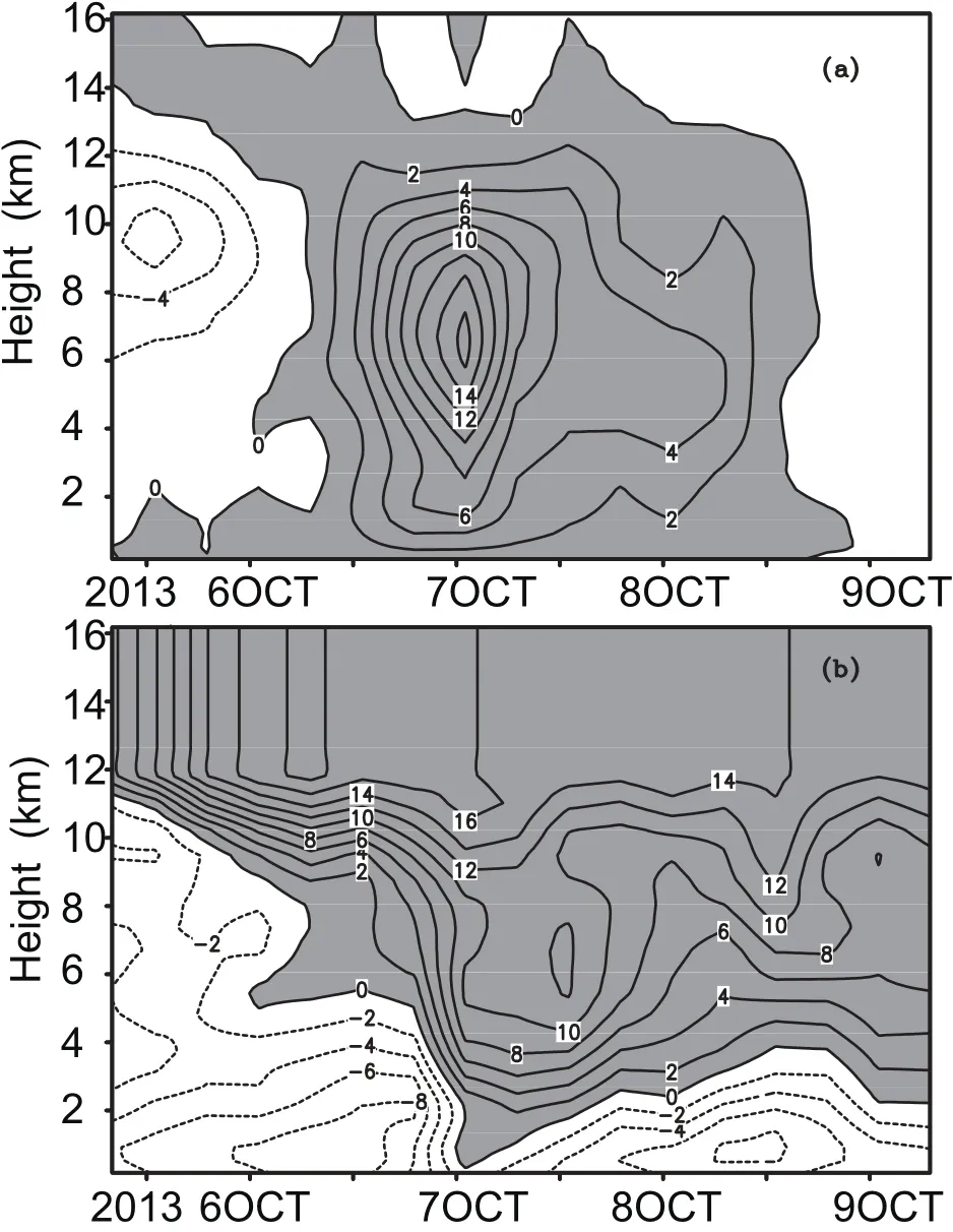
Fig.2.Temporal and vertical distribution of(a)vertical velocity(units:cm s?1)and(b)meridionalw ind(units:m s?1)from 0800 LST 5 October to 0800 LST 9 October 2013.Ascending motion in(a)and westerly w ind in(b)are shaded.The data are averaged in a rectangular box covering(26°–34°N,118°–122°E).

Table 2.Summary of the(a)experimentdesignsand(b)differences between experiments.
3. The controlexperiment
Theevolution of the simulated rain rateaveraged over the model domain in CTL is generally sim ilar to that of the observed rain rate averaged over the rectangular box covering (26°–34°N,118°–122°E)(Fig.1).The root-mean squared difference(RMSD)between the observed and simulated rain rate in CTL(1.14mm h?1)is significantly smaller than the standard deviation of the observed rain rate(1.84mm h?1). Compared to the observed rain rate,the simulated rain rate shows significant short-term variability(Fig.3).Li et al. (2002)also revealed a short-term life span(nine hours)of convection in their 2D cloud-resolvingmodel simulation of tropical rainfall.They argued that the short-term life span isattributable to themodelphysics.Themean simulated rain rate can beanalyzed based on thesurface rainfallbudget(Gao etal.,2005;Cuiand Li,2006):

Here,themean rain rate isassociatedw ith drying(QWVT>0) or moistening(QWVT<0)of the local atmosphere,water vapor convergence(QWVF>0)or divergence(QWVF<0), surfaceevaporation(QWVE),and cloud hydrometeor lossand convergence(QCM>0)orgain and divergence(QCM<0).
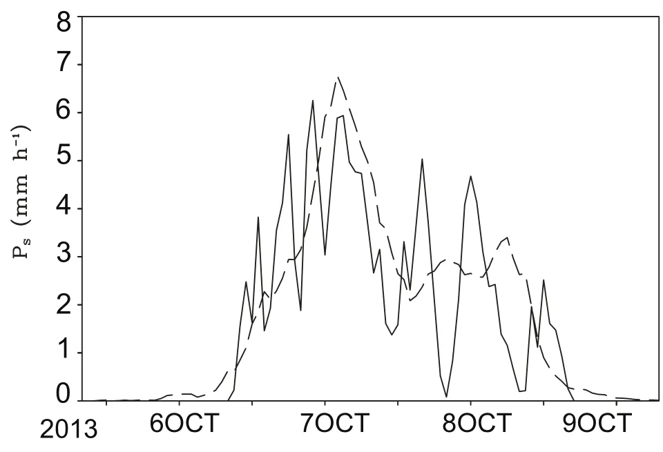
Fig.3.Surface rain rate(units:mm h?1)simulated in CTL (solid)and from rain gauge observation(dashed).

Fig.4.Time seriesofmodeldomainmeansof the surface rainfall budget in CTL:PS(black);QWVT(orange);QWVF(blue); QWVE(green);QCM(red).Units:mm h?1.
The short-term variability of the mean simulated mean rain rate is related to those of the local change in water vapor(QWVT)and clouds(QCM),whilewater vapor convergenceassociated w ith the imposed large-scale verticalvelocity largely determ ines theevolution of themean rain rate(Fig. 4).The time scale of the variability of QCMis smaller than thatof QWVT.The timescaleof themean rain ratevariability correspondsmainly to thatof QWVT.Before the occurrence of strong rainfall on 5 October and in the early morning of 6 October,themean water vapor convergence fails to produce the rainfall because itmoistens the local atmosphere, which sets favorablemoisture conditions for thedevelopment of torrential rainfall later.In the latter part of the day on 8 Octoberand theearly partof9October,thewatervapor convergence decreases rapidly,which leads to the dissipation of strong convection.
The model domain can be categorized into clear-sky, raining stratiform,convective,and non-raining stratiform regions.The area w ith a total hydrometeormixing ratio of over 10?5g kg?1is considered cloudy.The convective and stratiform rainfall is partitioned using the scheme developed by Tao etal.(1993)andmodified by Suietal.(1994).Over clear-sky regions,watervaporconvergence isused tomoisten the localatmospherebefore thebeginning of the rainfall(Fig. 5a).Water vapor divergence generally occurs before the torrential rainfall reaches amaximum ataroundmidnightof 6 October,which leads to drying of the localatmosphere.Water vapor convergence generally occurs after themaximum rainfall,which moistens the local atmosphere.Over raining stratiform regions,watervaporconvergence,atmospheric drying and hydrometeor convergence are sources of stratiform rainfall(Fig.5b).Over convective regions,convective rainfall is largely associated w ith water vapor convergence (Fig.5c).Over non-raining stratiform regions,water vapor convergence is generally used to increasewater vapor in the localatmosphere(Fig.5d).

Fig.5.Timeseriesof surface rainfallbudget[PS(black),QWVT(orange),QWVF(blue),QWVE(green)and QCM(red)]in (a)clear-sky,(b)raining stratiform,(c)convective and(d) non-raining stratiform regions,calculated from CTL.Units: mm h?1.
4. Cloudm icrophysicaland rainfall responses to radiative processes
The RMSDs between the observed and simulated rain rates in NWR(0.87mm h?1),NIR(0.90mm h?1)and NCR (0.94mm h?1)are about18%–24%smaller than thatin CTL (1.14mm h?1).This indicates that the removalof cloud radiativeeffects leads to better rainfallsimulationscompared to theobservation.TheRMSDsmay beattributable to theerrors from rain gaugeobservations,the large-scaleverticalvelocity from the NCEP/GDAS data,and the initial conditions.The reduction in RMSD caused by the exclusion of cloud radiative effects implies that the errors from othermodel physics, such as the releaseof latentheatassociatedw ith cloudm icrophysicalparameterization schemesand heatdivergence,may compensate for the errors from the radiative tendency due to the removalof cloud radiativeeffects in the thermalbalance.
The impactsof radiativeprocesseson cloudm icrophysics and rainfall are investigated through analysis of four-day and model domain average data.The exclusion of radiative effects ofwater clouds increases the rain rate from CTL to NWR in the presence of radiative effects of ice clouds, whereas itbarely changes the rain rate from NIR to NCR in the absence of radiative effectsof ice clouds(Table3).
To exam ine the change in cloud processes that are responsible for thechange in rainfall,themeanmass-integrated cloud budget isanalyzed.The cloud budget isexpressed by

Here,QNCis thenetcondensation,and the cloudmicrophysical termson the right-hand side of Eq.(2b)can be found in Table 1.Themean hydrometeor change(QCM)can be broken down into themean hydrometeor change in cloud water (QCMC),raindrops(QCMR),cloud ice(QCMI),snow(QCMS), and graupel(QCMG).
The increase in the rain rate from CTL to NWR isassociatedw ith theenhancementin hydrometeor loss,while thenet condensation rates are similar in the two experiments.The sim ilar rain rate in NIR and NCR corresponds to similar net condensation and hydrometeor loss.
The sim ilar net condensation rates in CTL and NWR, and in NIR and NCR,are related to the offset between the increases in the vapor condensation(PCND)and evaporation of rain(PREVP)(Table 4).The increase in hydrometeor loss from CTL to NWR corresponds to the change in graupel from again in CTL to a loss in NWR(Table5),which corresponds mainly to the decrease in accretion of raindropsby cloud ice(PIACR)(Table 6).The reduction in PIACRmay be related to the decrease in cloud ice,which corresponds to the weakened vapor deposition(PDEP)as a result of the increase in saturation specific hum idity associated w ith suppressed infrared radiative cooling at around 6–10 km(Fig.6).Note that the difference in radiative tendency is determ ined by thedifference in infrared radiative cooling because thedifference in solar radiative heating is generallymuch smaller than the difference in infrared radiative cooling(not shown).Compared to CTL,The removalof radiativeeffectsofwatercloud in NWR allows radiation em itted from the lower troposphere to reach the bottom of ice clouds,and the radiative effects of ice clouds trap radiation to suppress the infrared radiative cooling in them id and upper troposphere from CTL to NWR.

Table 3.Cloud microphysical budgets(PS,QNC,and QCM)averaged for four days over the model domain and their RI and FRC(a)in CTL,NWR,NIR and NCR,and(b)their differences (NWR?CTL,NCR?NIR,NIR?CTL and NCR?NWR).Units aremm d?1for the cloudm icrophysical budgetand RI,and%for FRC.________________________________________________

Table 4.Breakdown of QNCinto PCND,PDEP,PSDEP,PGDEP,?PREVP,?PMLTSand?PMLTGaveraged over themodeldomain and fourdays(a)in CTL,NWR,NIR and NCR,and(b)theirdifferences (NWR?CTL,NCR?NIR,NIR?CTL and NCR?NWR).Units: mm d?1._______________________________________________
Table 5.(a)Breakdown of Q CMinto Q CMC,Q CMR,Q CMI,Q CMS and QCMGin CTL,NWR,NIR and NCR,and(b)their difference forNWR?CTL and NCR?NIR.Units:mm d?1.
Table 6.Four-daymean QCMG(units:mm d?1)in CTL and NWR and their difference for NWR?CTL.QCMG=?PGACI(T<To)?P GACW(T<T o)?P GACS?P LACR(T<T o)?P GACR(T<T o)?P WACS(T<T o)+P GMLT(T>T o)?P GDEP(T<T o)+P MLTG(T>To).(To=0°C)
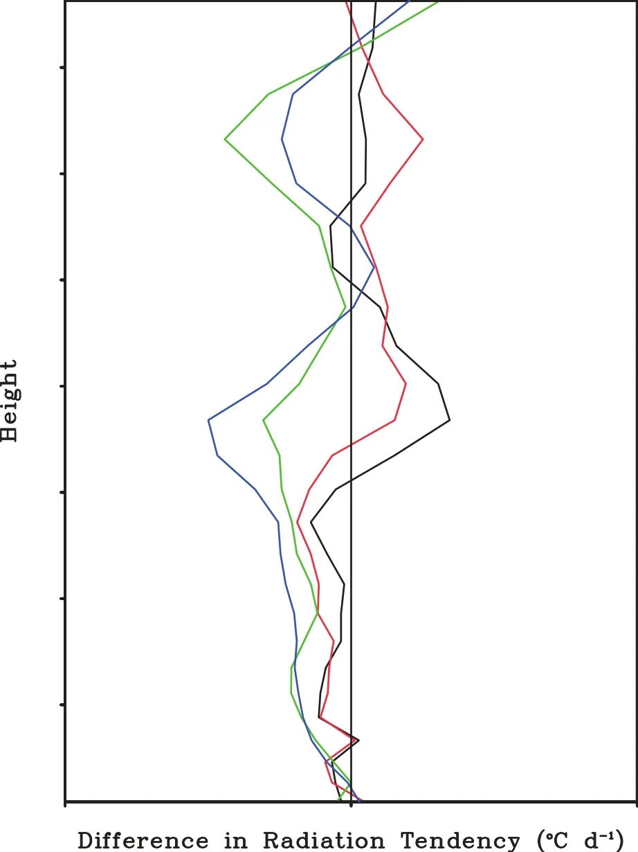
Fig.6.Vertical profi les of difference in radiation tendency for NWR?CTL(black),NCR?NIR(red),NIR?CTL(green),and NCR?NWR(blue),averaged over four days.Units:°C d?1.
The similar hydrometeor loss in NIR and NCR is due to the fact that the changes in cloudwaterand snow from again in NIR to a loss in NCR aremainly balanced by the decrease in raindrop loss.The changes in cloud water and snow from a gain in NIR to a loss in NCR aremainly associated w ith the increase in the collection of cloud waterby rain(PRACW) and accretion of snow by graupel(PGACS),respectively(Tables 7 and 8).The decrease in raindrop loss from NIR to NCR is related to the reduction in rain source through the increase in PRACW(Table 9).The increase in PRACWcorresponds to enhanced vapor condensation(PCND)through the reduction in saturation specific hum idity associated w ith the enhanced infrared radiative cooling from NIR to NCR in the lower troposphere(Fig.6).The increase in PGACSis related to the increase in snow,while graupeldecreases from NIR to NCR.The increase in snow is related to the increased snow source from the accretion of cloud water(PSACW)and raindrops(PSACR)by snow through the increases in cloud water and raindrops associated w ith the increase in PCND.A lthough radiative effects of ice clouds are excluded in both NIR and NCR,water vapor traps the radiation emitted from the lower troposphere in NCR to slightlyweaken infrared radiative cooling in theupper troposphere from NIR to NCR.

Table 7.Four-daymean QCMC(units:mm d?1)in NIR and NCR and their difference for NCR?NIR.QCMC=PSACW+PRAUT+ P RACW+P GACW?P CND+P IHOM(T<T oo).(T oo=?35°C).
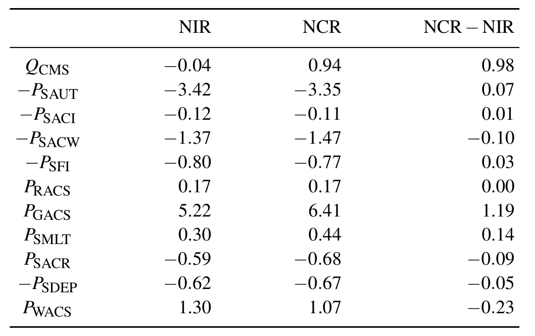
Table 8.Four-daymean QCMS(units:mm d?1)in NIR and NCR and their difference for NCR?NIR.QCMS=?PSAUT(T<To)?P SACI(T<T o)?P SACW(T<T o)?P SFI(T<T o)+P RACS(T>T o)+P GACS+P SMLT(T>T o)?P SACR(T<T o)?P SDEP(T<T o)+ P WACS(T<T o).

Table 9.Four-daymean QCMR(units:mm d?1)in NIR and NCR and their difference for NCR?NIR.QCMR=?PRAUT?PRACW?P GACW(T>T o)+P REVP?P RACS(T>T o)+P LACR(T<T o)+ P GACR(T<T o)?P SMLT(T>T o)?P GMLT(T>T o)+P S.
The removal of radiative effects of ice clouds strengthens the rain rate primarily through the increases in net condensation from CTL to NIR and NWR to NCR(Table 3). The enhancement in net condensation corresponds to the increase in PCND(Table 4)through the decrease in saturation specific humidity associated w ith the enhanced infrared radiative cooling from CTL to NIR and NWR to NCR(Fig. 6)caused primarily by the exclusion of radiative effects of ice clouds.Compared to NWR,the removalof the effects of water clouds in NCRmakes atmospheric layersmore transparent to the radiation emitted from the lower troposphere and leads to more radiation escaping.As a result,the enhancement in infrared radiative cooling from NWR to NCR isstronger than that from NIR to CTL.
The enhancement in rainfall decreases from NIR?CTL to NCR?NWR through the change from the increase in hydrometeor loss for NIR?CTL to the decrease in hydrometeor loss for NCR?NWR(Table 3).The increase in rainfall dramatically reduces from NWR?CTL to NCR?NIR via the slowdown in the enhanced hydrometeor loss.These resultscorrespond primarily to thedecrease in PIACRfrom CTL to NWR,while the decrease in PIACRfrom NIR to NCR is relatively small(Table 5).The reduction in PIACRfrom CTL to NWR is associated w ith the suppressed infrared radiative cooling(Fig.6).
Pingetal.(2011)conducted asimilarsetofsensitivity experiments to thoseperformed in thisstudy but,in theirexperiments,zero large-scale verticalvelocity and height-invariant zonalw ind and time-invariant sea surface temperature were imposed in the model during the equilibrium integrations. The similarity between the two studies is that rainfall increaseswhen radiative effects of water clouds are excluded in the presence of radiative effectsof ice clouds,orwhen radiative effectsof ice cloudsare removed[see Table 3 in this study and Table 2 in Ping etal.(2011)].The difference between the two studies is that in the absence of radiative effects of ice clouds,rainfall is insensitive to radiative effects ofwater clouds in thisstudy,whereas rainfall increaseswhen radiative effectsofwater cloudsare elim inated in Ping etal. (2011).
Following Lietal.(2015),themodel domainmean rain rate isaproductofRI(rain rateaverageover the rainfallarea) and FRC(the ratio of rain grids to totalmodeldomain grids), i.e.,

Like the aforementionedmodel domain rainfall responses to radiative processes,theexclusion of radiativeeffectsofwater clouds increases the RIfrom CTL to NWR(Table3).The removalof radiativeeffectsof ice clouds increases the RIfrom CTL to NIR and from NWR to NCR.Unlike the radiativeeffectsofwater cloudson rainfall from NIR to NCR,the elimination of radiative effects of water clouds decreases the RI from NIR to NCR.The FRC reduces from CTL to NWR,and from CTL to NIR and NWR to NCR,whereas it increases from NIR to NCR.
Lietal.(2014)defined themaximum rain rateas the sum of(1)localatmospheric drying and(2)water and hydrometeor convergence,based on rainfallseparation via the surface rainfall budget.We calculated themean cloud m icrophysical budget and RIand FRC associated w ith themaximum rainfall,and their responses to radiativeprocesses(Table10). Themean rainfall increases from CTL to NWR,and from CTL to NIR,mainly through theenhanced netcondensation; whereas,it reduces from NIR to NCR,and from NWR to NCR,via the suppressed net condensation.In contrast,the exclusion of radiative effects decreases themaximum RIregardlessofwateror ice clouds.
Based on Eq.(3),the difference in PS(y)and PS(x)can be w ritten as

Here,(y,x)=(NWR,CTL),(NCR,NIR),(NIR,CTL),(NCR, NWR).Table 11a shows that PS(y)?PS(x)is controlledby FRC(x)[RI(y)?RI(x)].This suggests that cloud radiative effects on model domain mean rainfall is interrelated w ith cloud radiative effects on RI.For maximum rainfall, PS(y)?PS(x)isdeterm ined by RI(x)[FRC(y)?FRC(x)](Table 11b).This indicates thatcloud radiative effectsonmodel domain meanmaximum rainfall correspond to cloud radiativeeffectson the fractionalcoverageofmaximum rainfall.
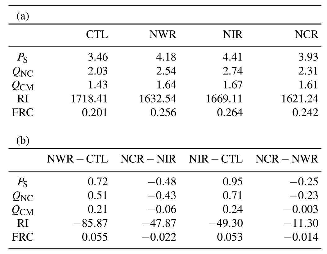
Table 10.Asin Table3but for thoseassociatedw ithmaximum rainfall.___________________________________________________

Table 11.Differences in(a)domain mean rain rate and(b)maximum rain rate for NWR?CTL,NCR?NIR,NIR?CTL and NCR?NWR,and their relationships to differences in RIand FRC. PS1=[RI(y)?RI(x)][FRC(y)?FRC(x)],PS2=RI(x)[FRC(y)?FRC(x)],PS3=FRC(x)[RI(y)?RI(x)].Units:mm d?1.
5. Summ ary
Cloud-resolving model sensitivity experiments of Typhoon Fitow(2013)were conducted to study the cloud microphysicaland rainfall responses to radiative processes during the typhoon’s landfall.The rain rate simulated in CTL was compared w ith observed rain gauge data.The analysis of the RMSD between simulation and observation,and the standard deviation,showed fairagreementbetween the simulation and observation.The comparison of themodeldomain mean cloud budget between the sensitivity experiments revealed that the exclusion of radiative effectsofwater clouds increases themean rainfall through the enhanced hydrometeor loss caused by the decrease in accretion of raindrops by cloud ice in the presence of radiative effects of ice clouds; whereas,it barely changes rainfall in the absence of radiative effectsof ice clouds.The removalof radiative effects of ice clouds increases themean rainfall through the strengthened net condensation regardless of the radiative effects of water clouds.Thedifference inmodeldomainmean rain rate caused by cloud radiative effects is related to the difference in RI.
Theincreasesinmaximum rainfallareassociatedw ith the exclusion of radiativeeffectsofwater clouds in the presence of radiative effects of ice clouds,or the removalof radiative effectsof ice clouds in thepresenceof radiativeeffectsofwater clouds,mainly through the enhancements in net condensation.The decreases inmaximum rainfall correspond to the elimination of radiativeeffectsofwatercloudsin theabsence of radiative effectsof ice clouds,or the removalof radiative effectsof ice clouds in theabsenceof radiativeeffectsofwater clouds,through the reductions in net condensation.The difference in themaximum rain ratecaused by cloud radiative effects is related to the difference in the fractional coverage ofmaximum rainfall.
Acknow ledgements.The authors thank Dr.W.-K.TAO at NASA/GSFC forhis cloud-resolvingmodel,and the Editor(Dr.Z. SUN)and the two reviewers for their constructive comments.This work was supported by the NationalNatural Science Foundation of China(GrantNo.41475039)and the National Key Basic Research and DevelopmentProjectof China(GrantNo.2015CB953601).
REFERENCES
Chou,M.-D.,1992:A solar radiation model for use in climate studies.J.Atmos.Sci.,49,762–772.
Chou,M.-D.,and M.J.Suarez,1994:An efficient thermal infrared radiation parameterization for use in general circulation model.NASA Tech.Memo.104606,Vol.3,85 pp. [Available from NASA/Goddard Space Flight Center,Code 913,Greenbelt,MD 20771.]
Chou,M.D.,D.P.Kratz,and W.Ridgway,1991:Infrared radiation parameterizations in numerical climatemodels.J.Climate,4,424–437.
Chou,M.D.,M.J.Suarez,C.H.Ho,M.M.H.Yan,and K.T.Lee, 1998:Parameterizations for cloud overlapping and shortwave single-scattering properties for use in general circulation and cloud ensemblemodels.J.Climate,11,202–214.
Cui,X.P.,and X.F.Li,2006:Roleof surface evaporation in surface rainfall processes.J.Geophys.Res.,111,D17112,doi: 10.1029/2005JD006876.
Dudhia,J.,1989:Numerical study of convection observed during the w intermonsoon experiment using amesoscale twodimensionalmodel.J.Atmos.Sci.,46,3077–3107.
Gao,S.T.,and X.F.Li,2008:Cloud-resolving Modeling ofConvective Processes.Springer,Dordrecht,206 pp.
Gao,S.T.,and X.F.Li,2010:Precipitation equations and their applications to the analysis of diurnal variation of tropical oceanic rainfall.J.Geophys.Res.,115,D08204,doi: 10.1029/2009JD012452.
Gao,S.T.,X.P.Cui,Y.S.Zhou,and X.F.Li,2005:Surface rainfallprocessesassimulated in a cloud-resolvingmodel.J. Geophys.Res.,110,D10202,doi:10.1029/2004JD005467.
Gao,S.T.,X.P.Cui,and X.F.Li,2009:A modeling study of diurnal rainfall variations during the 21-day period of TOGA COARE.Adv.Atmos.Sci.,26,895–905,doi:10.1007/ s00376-009-8123-6.
Grabowski,W.W.,X.Q.Wu,M.W.Moncrieff,and W.D.Hall, 1998:Cloud-resolvingmodel of tropical cloud systems during Phase IIIof GATE.Part II:Effects of resolution and the third spatialdimension.J.Atmos.Sci.,55,3264–3282.
Gray,W.M.,and R.W.Jacobson Jr.,1977:Diurnal variation of deep cumulus convection.Mon.Wea.Rev.,105,1171–1188.
Khairoutdinov,M.F.,and D.A.Randall,2003:Cloud-resolving modeling of the ARMsummer 1997 IOP:Model formulation,results,uncertainties,and sensitivities.J.Atmos.Sci.,60, 607–625.
Krueger,S.K.,Q.Fu,K.N.Liou,and H.-N.S.Chin,1995:Improvementof an ice-phasem icrophysics parameterization for use in numerical simulations of tropical convection.J.Appl. Meteor.,34,281–287.
Li,X.F.,and S.T.Gao,2011:Precipitation Modeling and Quantitative Analysis.Springer,Dordrecht,240 pp.
Li,X.F.,C.-H.Sui,K.-M.Lau,and M.-D.Chou,1999:Largescale forcing and cloud-radiation interaction in the tropical deep convective regime.J.Atmos.Sci.,56,3028–3042.
Li,X.F.,C.-H.Sui,and K.-M.Lau,2002:Dom inantcloudm icrophysical processes in a tropical oceanic convective system: A 2-D cloud resolvingmodeling study.Mon.Wea.Rev.,130, 2481–2491.
Li,X.F.,G.Q.Zhai,S.T.Gao,and X.Y.Shen,2014:A new convective-stratiform rainfall separation scheme.Atmos.Sci. Lett.,15,245–251.
Li,X.F.,G.Q.Zhai,P.J.Zhu,and R.Liu,2015:An equilibrium cloud-resolving modeling study of diurnal variation of tropical rainfall.Dyn.Atmos.Ocean,71,108–117.
Lilly,D.K.,1988:Cirrus outflow dynam ics.J.Atmos.Sci.,45, 1594–1605.
Lin,Y.-L.,R.D.Farley,and H.D.Orville,1983:Bulk parameterization of the snow field in a cloud model.J.Climate Appl. Meteor.,22,1065–1092.
Ping,F.,Z.Luo,and H.Wang,2011:Effects of ice and water clouds on rainfall:A partitioning analysis based on surface rainfallbudget.Atmos.Sci.Lett.,12,300-308.
Rutledge,S.A.,and P.V.Hobbs,1983:Themesoscale and m icroscalestructureand organizationofcloudsand precipitation inm idlatitude cyclones.Part VIII:A model for the“seederfeeder”process inwarm-frontal rainbands.J.Atmos.Sci.,40, 1185–1206.
Rutledge,S.A.,and P.V.Hobbs,1984:Themesoscale and m icroscale structure and organization of clouds and precipitation in m idlatitude cyclones.Part XII:A diagnostic modeling study of precipitation developmentin narrow cold-frontal rainbands.J.Atmos.Sci.,41,2949–2972.
Soong,S.T.,and Y.Ogura,1980:Response of tradew ind cumuli to large-scale processes.J.Atmos.Sci.,37,2035–2050.
Soong,S.T.,and W.-K.Tao,1980:Response of deep tropical cumulus clouds to Mesoscale processes.J.Atmos.Sci.,37, 2016–2034.
Sui,C.-H.,K.-M.Lau,W.-K.Tao,and J.Simpson,1994:The tropicalwater and energy cycles in a cumulus ensemblemodel. Part I:Equilibrium climate.J.Atmos.Sci.,51,711–728.
Sui,C.-H.,K.-M.Lau,Y.N.Takayabu,and D.Short,1997:Diurnal variations in tropical oceanic cumulus convection during TOGA COARE.J.Atmos.Sci.,54,639–655.
Sui,C.-H.,X.Li,and K.-M.Lau,1998:Radiative-convective processes in simulated diurnalvariationsof tropicaloceanic convection.J.Atmos.Sci.,55,2345–2359.
Sui,C.-H.,X.F.Li,M.-J.Yang,and H.-L.Huang,2005:Estimation of oceanic precipitation efficiency in cloudmodels.J. Atmos.Sci.,62,4358–4370.
Tao,W.K.,and S.T.Soong,1986:A study of the responseofdeep tropical clouds to mesoscale processes:Three-dimensional numericalexperiments.J.Atmos.Sci.,43,2653–2676.
Tao,W.-K.,and J.Simpson,1993:TheGoddard Cumulus Ensemblemodel.Part I:Modeldescription.TerrestrialAtmospheric and Oceanic Sciences,4,35–72.
Tao,W.-K.,J.Simpson,and S.-T.Soong,1987:Statisticalproperties of a cloud ensemble:A numerical study.J.Atmos.Sci., 44,3175–3187.
Tao,W.-K,J.Simpson,and M.McCumber,1989:An ice-water saturation adjustment.Mon.Wea.Rev.,117,231–235.
Tao,W.K.,J.Simpson,C.H.Sui,B.Ferrier,S.Lang,J.Scala, M.D.Chou,and K.Pickering,1993:Heating,moisture,and water budgets of tropicalandm idlatitude squall lines:Comparisonsand sensitivity to longwave radiation.J.Atmos.Sci., 50,673–690.
Tompkins,A.M.,2000:The impact of dimensionality on longterm cloud-resolving model simulations.Mon.Wea.Rev., 128,1521–1535.
3 June 2015;revised 23 July 2015;accepted 26 July 2015)
:Lou,L.Y.,and X.F.Li,2016:Radiative effectson torrential rainfallduring the landfallof Typhoon Fitow(2013). Adv.Atmos.Sci.,33(1),101–109,
10.1007/s00376-015-5139-y.
?Corresponding author:Xiaofan LI
Email:xiaofanli@zju.edu.cn
 Advances in Atmospheric Sciences2016年1期
- Advances in Atmospheric Sciences的其它文章
- Revisiting the Second EOFMode of Interannual Variation in Summer Rainfallover East China
- Evolution of Instability before and during a Torrential Rainstorm in North China
- Simulation of Quasi-Linear Mesoscale Convective System s in Northern China: Lightning Activitiesand Storm Structure
- Verification and Correction of Cloud Base and Top Height Retrievals from Ka–band Cloud Radar in Boseong,Korea
- Effectsof Surface Flux Parameterization on the Numerically Simulated Intensity and Structureof Typhoon Morakot(2009)
- Teleconnected Influenceof the BorealW inter Antarctic Oscillation on the Somali Jet:Bridging Role of Sea Surface Tem perature in Southern High and Midd le Latitudes